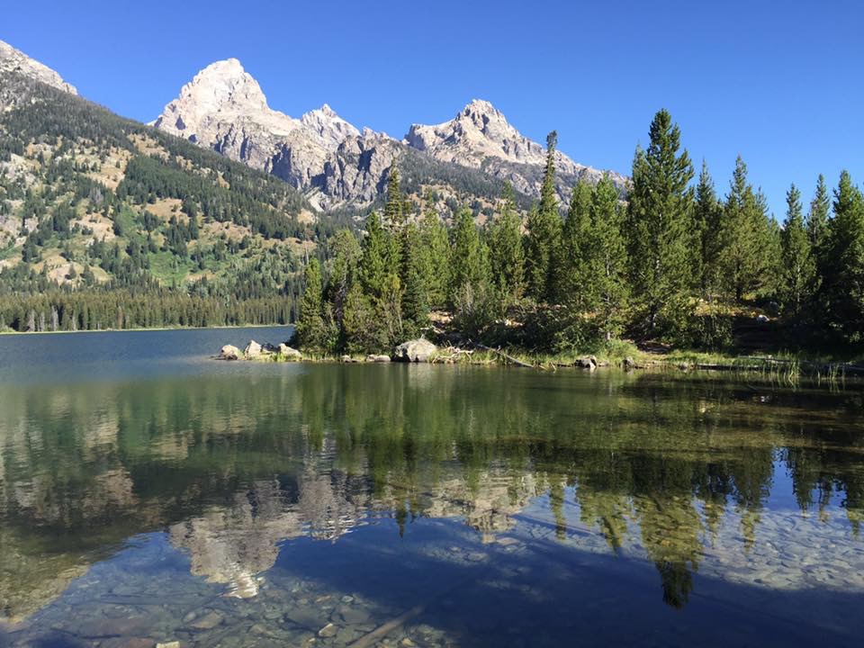
After six weeks working in Skagway, Alaska, we will be hitching up and pulling out tomorrow, September 22!! We were originally scheduled to work until 9/22, but the cruise ships scheduled to arrive in port both today and tomorrow, have cancelled due to storms. And speaking of storms, we did have several people ask if we were in the path of the large storm that just struck Alaska. Just to give you an idea of the size of Alaska, the storm hit over 1,000 miles North of where we are. But it is affecting the ships out at sea.
We spent today packing up and getting ready to depart. Tomorrow we will be crossing back into Canada, and heading down to the lower 48. Our final destination will be Yuma, Arizona, 3000 miles from Skagway. We need to arrive by October 13, for a work campers meeting at Westwind Golf and RV Resort. We will be back working at the Golf Pro Shop two days a week at the resort.
We have enjoyed our time working for Corrington Enterprises at the Skagway Outlet Store, and it was nice having money go in to the bank account, instead of coming out. Our friends Tom and Ellen, along with Rodney and Susan will also be leaving tomorrow, and we will be traveling together for about 5 days. Rodney and Susan are going to work at the Beet Harvest, as they enjoyed doing that last year. Tom and Ellen will also be heading to Yuma, and we will be traveling with them on and off. We have an oil changed scheduled in Conrad, Montana for the motorhome, and they have some other appointments scheduled as well, but will eventually meet back up in Utah at some point.
Originally we planned on taking the Cassier Highway down through British Columbia, but have changed plans and will be taking the Alaska Highway back through Canada. It will be the same way we came up. A few weeks ago, there was an accident involving a tanker truck that caught on fire and heavily damaged a bridge on the Alaska Highway. The bridge is back open, but tractor-trailers are still not allowed to cross over the bridge. That means the Cassier Highway will be the main route for the semi’s coming up north. We decided to avoid that road as a result.
Even though we have been busy working six days a week (gotta love the overtime!), we did manage a few fun nights out with Tom and Ellen at the local Eagles Club, where Tom is a member. Skagway has the oldest Eagles Club in Alaska, and is club number 25 in the United States. I believe this branch was founded in 1898.
Tom, Jonell and Ellen
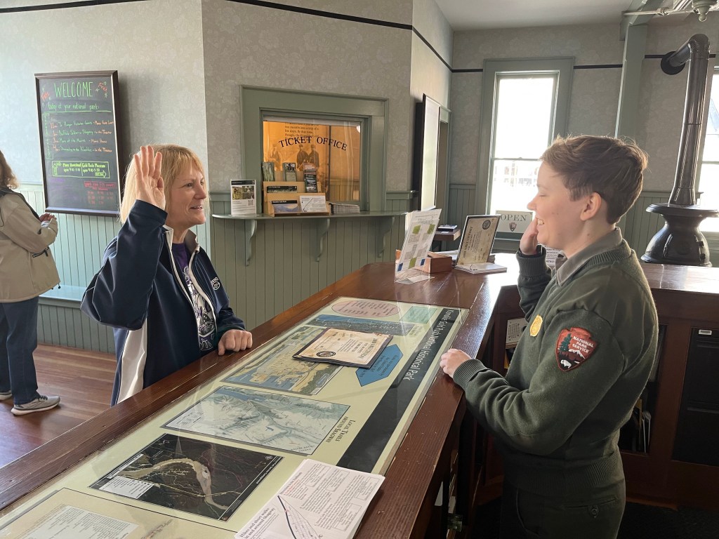
Many people think Skagway is owned by the cruise ship companies, but only two stores in town are owned by the cruise ships. The majority of the town is owned by the National Park Service, as it is home to the Klondike Gold Rush National Historical Park. The park service has been working to restore many historical buildings and has a very informative movie on the origins of Skagway and the Klondike Gold Rush.
And with it being a national park, there is also a Junior Ranger program, so I spent some time completing the program, and getting my Junior Ranger Badge!
As I have mentioned before, I am woefully behind in my Alaska blogs. Once we cross back into Canada tomorrow, we will be back on 0.5 GB, courtesy of our Verizon plan, so I won’t be doing any further blogs until we cross back into the United States at the end of the month. But I will try and do some Instagram updates.
AUGUST GAS EXPENSES
We travelled 811 miles in August in the motorhome, spending $698.14 on gasoline. Gas dropped over $1.00/gallon since July, which was helpful on the fuel budget. And we have sat still for six weeks, which also helps out.
AUGUST CAMPGROUND EXPENSES
For the 30 days in August, we had 10 nights of paid camping, at a cost of $491.56 ($49.16 night) and 20 nights of free camping as part of our work camping compensation. Overall, this works out to a cost of $16.39/per night.
AUGUST ENTERTAINMENT EXPENSES
We spent a total of $235.90 on museums in Fairbanks and a bus tour in Denali National Park for the month of August.
AUGUST INSTAGRAM POSTS
For those not on Instagram, these are the posts that I made in August.
Hello everyone! It’s me, Makena, your favorite dog blogger.
Keeping my peeps informed!
I’m still in Alaska, and my parents have gone back to work for a few weeks. I’m quite happy about this, because I need to make sure they can keep my belly full of food and treats. They work, so I can have a good life!
I’m also a creature of habit, so staying in one place for a few weeks is better for my routine. I love traveling, checking out all the new smells as we move around, but all that time in my crate was getting a bit much for me. At 15, I’m not a spring chicken anymore! I love chicken, by the way…
Before we left Yuma, Arizona to go on this extended vacation, my mom calculated how much dry and canned dog food I would need. I can get 4 meals out of one can, so my mom had Chewy.com deliver enough food to last me through my trip.
Now that we are staying longer, I was concerned about running out. My mom went to order from Chewy for the remainder of our visit, only to discover they do not ship to Alaska. What?! I went into panic mode, thinking they were going to ration out my canned food. But my parents found a Petco store in Fairbanks that has my brand of food, so they stocked up again (at quite a higher price than Chewy). So I’m all good now!
Apparently dogs and cats in Alaska are Seattle Seahawks fans, as they had a large display of apparel in the Petco store.
Ummm…no
There is only one team worthy of my affection!
Go Pack Go!
I spent the summer hanging out with my buddy Cody. We said our goodbyes before he headed back to Florida with his parents.
Goodbye Cody!
But then that darn boy dog decided to give me a big smooch! Geez, I’m not that kind of girl…
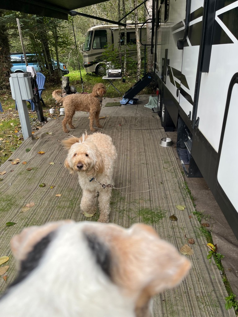
I’m now back with my pals Finn and Duffy. I like to keep my eye on them from a safe distance.
And just so they know not to cross over into my turf, I made sure to mark the boundaries.
I’m looking forward to getting back on the road in a few weeks. I love exploring. I also like warm and sunny weather,\. It’s too chilly for this old gal to be hanging outside. My only complaint here in Skagway is the fact that my parents work until 5:30 pm, so my 5:00 canned food time gets delayed. But they are promising me both warm weather, and prompt dinner in the future, so I’m going to be patient.
Quote of the day: “If life were predictable, it would cease to be life, and be without flavor.” – Eleanor Roosevelt
By staying longer in Alaska, we were hoping for an opportunity to the the Aurora Borealis, also known as The Northern Lights. One of the better areas in Alaska to see it is in Fairbanks. We were there in early August, but it was still light out until midnight, and then stayed in twilight until sunrise. It was just never dark enough to view it while we were there.
Skagway is 700 miles south of Fairbanks, and the first thing that surprised us when we arrived here in mid-August was how dark it got after 10 pm. It was the first time since early June that we actually had dark skies.
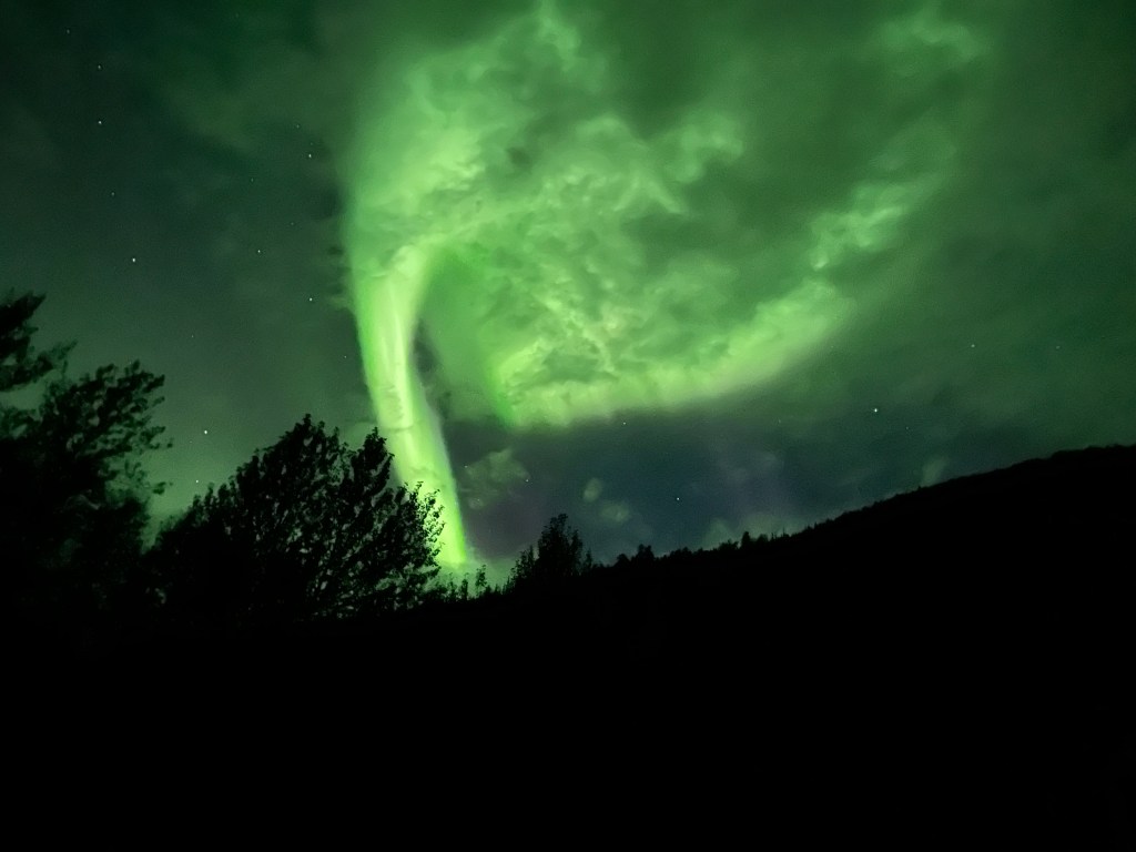
We have had mostly cloudy (and rainy) days and nights here in Skagway, so we were not sure we would see any lights until we left Skagway and headed back into Canada. We have downloaded the app, My Aurora Forecast, and it said Saturday night in Skagway was a 6 on the KP scale (goes from 0 to 9). This is the highest it has been since we arrived, so we were slightly optimistic, if the clouds would stay away. Dan went and looked at the sky after 10 pm, but did not see anything.
Around 10:30 pm, I heard our neighbor Tom yelling “the lights are out!” So we grabbed our cell phones and headed outside the RV for an amazing show! If you want more information on what causes the lights, check out The Northern Lights Center information page here https://www.northernlightscentre.ca/northernlights.html
To put the photos in perspective, this is where we were standing, in the employee campground. I took these two photos around 6:15 this morning.
Here’s our light show last night, even with it being partly cloudy. All the photos are taken with our IPhones.
If you look closely at the photo below, the Big Dipper is also present in the lower right hand corner.
SPECIAL VISITORS!
Another highlight of our Saturday was a surprise visit from our friends Dave, Marilyn, Jim and Carol from Yuma! They were on an Alaskan cruise to celebrate Dave and Marilyn’s 60th wedding anniversary! Their boat arrived in Skagway for the day, and they called Tom when they arrived in town to pick them up. It was a complete surprise for all of us! We had a wonderful visit, and then Tom drove them back to the docks.
Jim, Carol, Jonell, Tom, Ellen, Marilyn and Dave
It was a truly special day! We hope to see the lights again, before we enter back in the lower 48. It would be nice to see them on the horizon next time.
Quote for the day: “It is good to feel small beneath the sparkling northern lights, small beside the mighty river. Nature is so close to us up here. My troubles and difficulties just shrivel up. I like being insignificant.” – Asa Larsson
We are back to work! In Alaska! When we were planning this trip, Dan and I had always talked about getting an end of season job while we were in Alaska. We have been full-time RVing for 9 years now, and this was the first summer that we were “taking off.” Around mid-July, we started discussing what we were going to do after visiting Fairbanks, our last stop in Alaska.
I contacted our friends Tom and Ellen that are working in Skagway, and they put us in contact with the general manager of the company that they are working for. (You may remember we did a quick side trip to Skagway to see them, the town and the stores they work at.) We spoke with the general manager of the five family owned stores about the possibility of finishing out the season, and she was thrilled to have us come and work for them, as they had high school and college students that would be leaving in August.
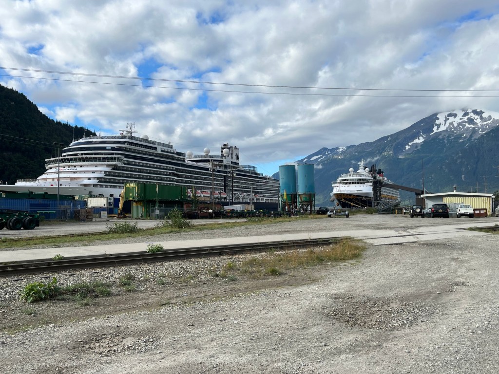
So we are now working full-time for the Corrington Ivory Company. They have five gift stores in Skagway. Every day up to three cruise ships come in to port in the morning, and depart early evening. Passenger totals for the three ships can be up to 9,000 people. So we are keeping busy!
Two ships in port
I was hoping to have more time to get caught up on the blogs, but there is only one cell tower in town for Verizon, and it gets heavy use when the ships are in port. Some days it feels like we are back to “dial up” service! I will keep plugging away though.
We will go back to “tourist mode” after September 22, and travel back down through Canada. This winter we will again be in Yuma, Arizona, so we still have another 3,000 miles to travel when we leave Skagway.
If you are considering traveling to Alaska, but are concerned about the costs, getting an end of season job is a great way to offset the expense. And there are plenty of jobs. Everyone is looking for help, especially end of season when school starts back up. We saw plenty of openings in all the cities we traveled through.
We will be paid $13.00 an hour, with a $2.00 per hour end of season bonus. Plus, we receive a free campsite, with full hook-ups, including 50 amp service. It will be nice to have money coming in, instead of going out for a change! Alaska does not have a state income tax, so we will not need to file a state tax form in the spring.
May I help you!Our gift shopPopular gift items
Karen and Al came down to visit Skagway for the day, and then we said our good-byes. They are making their way back to Florida (another 5,000 miles!) with stops along the way. We had a wonderful summer traveling with them, as you will see in my future blog posts.
Quote of the day: “If you don’t want to work you have to work to earn enough money so that you won’t have to work.” – Ogden Nash
Back when we were still in Canada in mid-May, we were parked next to a couple from British Columbia at a campground that was on their way back from a month long trip to Alaska. They told us the highlight of their time in Alaska was a sightseeing trip on the LuLu Bell boat out of Valdez.
We had already scheduled a sightseeing boat trip out of Seward, so I wasn’t sure I wanted to do two of these trips (at $170/person they are not cheap!) but I am so glad we did. Karen and Al also decided to add this to our trip too. I knew it was going to be a good day when I walked Makena before we left, and saw two Eagles hanging out on the antennae in our campground.
The four of us walked down to the docks from our campground, and we departed around 10 am on a foggy morning.
Lu Lu Belle in Valdez, ALaska
Sea lions greeted our boat on the way out of the harbor towards Prince William Sound.
Sea lions
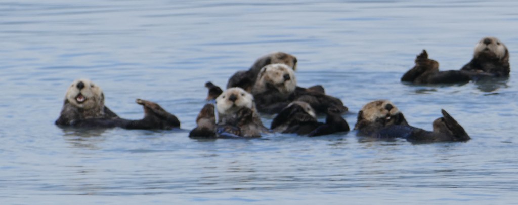
We saw several groups of sea otters throughout the day. I have never seen these before. They are a happy group and always seemed more curious than afraid of the boats.
Hello visitors
You never know what you are going to see on a cruise, and we were hopeful for a whale sighting. There was a lot of shouting going on by some of the passengers, when they noticed this “water spout!” We continued to watch and finally the humpback whale surfaced and then went back down. They can stay underwater a long time before surfacing. The captain timed this one, and it would stay under the water 6 minutes before surfacing.
Water spout Just a glimpseFirst whale tail
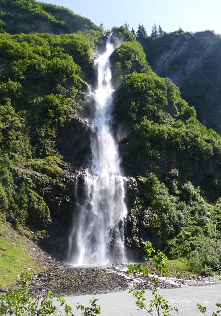
Later in the morning, the fog was lifting and the sun popped out for the day! We continued along the coast of Prince William Sound and came across a beautiful waterfall, Anderson Falls.
Anderson Falls
Being on a smaller style boat, the captain was able to navigate close to the rocky shoreline, and in and out of some tiny caves.
Cave with skylight
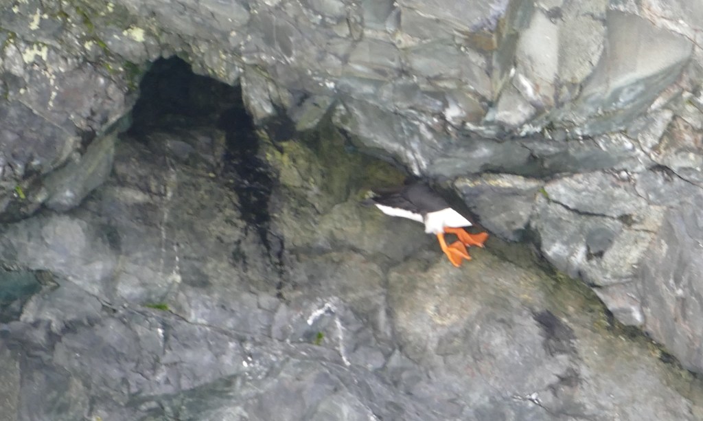
The captain was searching along the caves for birds, as that is where they like to hang out, especially the Puffin, which I really wanted to see. We did see dozens of them, but I was never able to get a clear photo. They like to hide in the nooks and crannies of the rocks, and then fly away fast. This photo is the best I could get! I call it my “butt” puffin! This is how they hang out.
“Butt” puffin!
This is a photo from the internet of the puffin. There are two types: horned and tufted.
We were fortunate to see a second whale, and watched it for a while.
Second whale tail
We encountered a very large group of sea lions sunning and playing along the rocks. They can get up to 1500 pounds, and love eating salmon. The locals are not fans of the sea lions because they eat so much of “their” fish.
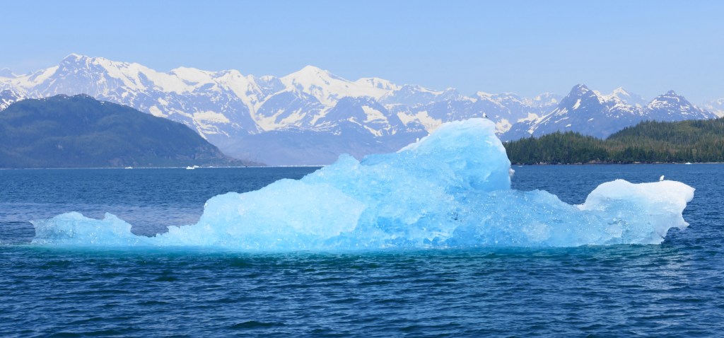
This is an untouched photo. The Chugach Mountain range is many miles away, but this beautiful blue piece of ice was just floating along the water. The captain estimated it calved from the glacier months ago, as it was several miles away from Columbia Glacier.
Amazing!
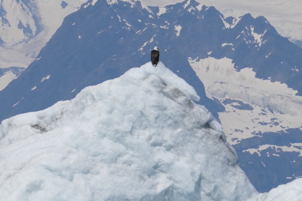
We came across another big iceberg, and there was an Eagle sitting on it, in the upper left side.
As we got closer, it flew away.
It was really an amazing cruise, and we still had another hour to get up close to the glacier. It was also starting to get pretty cold, even though it is bright and sunny out!
The captain did an excellent job navigating around all the icebergs and growlers, which are the smaller pieces of ice.
More sea ottersDarn tourists!
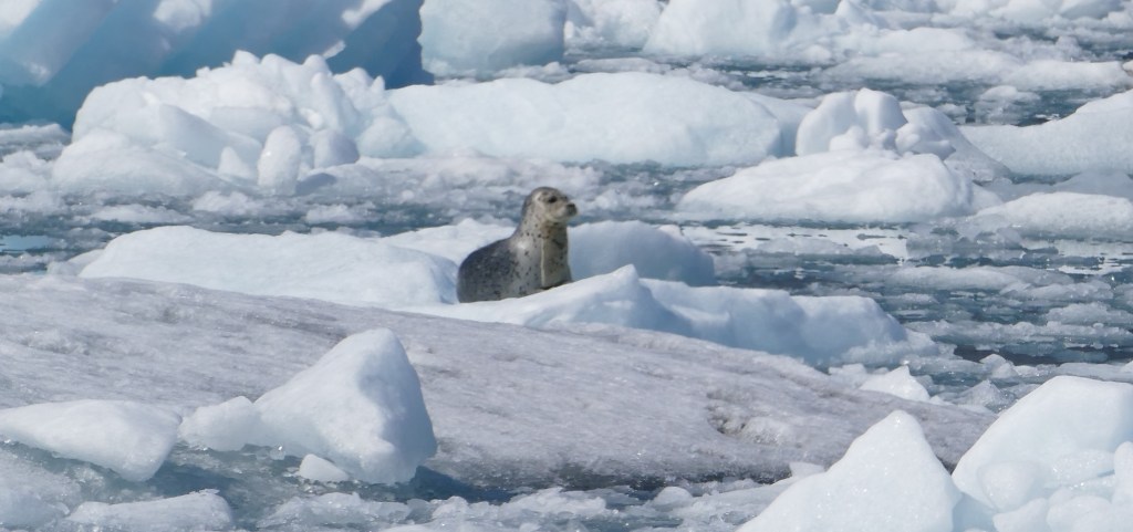
Closer to the glacier the number of growlers increased, and we started to see Harbor Seals.
Harbor seals
Our first view of the Columbia Glacier with the Chugach Mountains in the background. The Columbia Glacier is one of the most rapidly changing glaciers in the world. Since 1980 it has retreated 12 miles.
Zoomed in photo of the terminus of the glacier. The wall is 300 feet high.
The glacier is frequently calving, causing the water to be full of icebergs, making it difficult to get close to the glacier itself. The captain was able to get about 1/4 mile away.
The captain anchored the boat for a while, and the crew took photos for the guests. At this point, it was 37 degrees outside! I wish I would have brought my winter coat.
Columbia Glacier
On our way back to the harbor in Valdez, we continued to pass amazing icebergs!
Saw some mountain goats on the cliffs.
Mountain goats
And had a closer look at the terminal for the Alaska Pipeline.
Alyeska Pipeline Terminal
By the time we returned to the dock, it was close to 9 pm (even though the pipeline photo looks like mid-afternoon!). It was a long, chilly day, but definitely worth it. A lifetime of memories from this cruise alone.
Quote of the day: “If you can’t be in awe of Mother Nature, there is something wrong with you.” – Alex Trebek
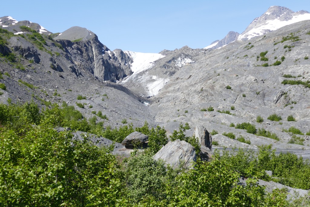
Valdez, due to the large amount of snow they receive, is considered the Land of Waterfalls in the spring and summer, when the snow begins to melt. Driving south on the Richardson Highway towards Valdez is a beautiful drive. We had our first glacier sighting, right from the road. The Worthington Glacier is considered to be the most accessible glacier in Alaska, since it is visible right from the highway.
This is the photo I took as we were driving by in our motorhome.
Worthington Glacier
Continuing down the highway into Valdez, you will pass through Keystone Canyon, which has many waterfalls.
Bridal Veil Falls
Horse Tail FallsKeystone Canyon
When the Kennecott Mine started operating, several cities tried to build a railroad, including Valdez. Unfortunately there were too many companies in the area fighting for the rights. And in true “Wild West” fashion, a gunfight took place, and the route was never finished. We stopped to explore the tunnel that was partially finished.
Unfinished tunnelUnfinished tunnel
After we were all settled in to Valdez, we drove back out to the Worthington Glacier to see it up close. But honestly, I thought the initial view of it driving in was the best view, as you could see the ice fields surrounding it. Below is a view from the overlook in the parking lot. Compare that to the one above on our drive in.
There is a walking path towards the glacier, and you can see the glacier lake that has formed from the melting over the years.
Zoomed in photos of the glacier. Notice the blue ice.
Quote of the day: “Sunshine is delicious, rain is refreshing, wind braces us up, snow is exhilarating; there is really no such thing as bad weather, only different kinds of good weather.” – John Ruskin
Two Alaska Native Tribes resided in the area of Valdez. The Chugach people to the south, and Ahtna to the north. The area was used for trade. In 1779, Captain Cook sailed into the Sound, and named the inland waters, Sandwich Sound. It was later renamed Prince William Sound, after Prince William IV.
Gold seekers started coming into Prince William Sound, and a lighthouse was built about 88 miles from Valdez, to guide the mariners safe passage into the area. The museum has a Fresnel lens on display that used an incandescent oil vaper lamp as its light source. The beam could been seen for 22 miles.
The gold rush seekers formed a tent city, and Valdez was born. As time went on, the city continued developing. The first highway in Alaska, the Richardson Highway, started in Valdez all the way to Fairbanks.
Winters can make road traffic impossible, and the museum honors the bush pilots that will have flown supplies during extreme weather conditions. Below are the outfits that were used in the 1920’s to 1940’s.
Cities need fire protection, and Valdez purchased this 1886 Gleason and Bailey Hand Pumped Fire Engine in 1902, when the city was three years old. It could pump water from a well or creek, or its internal tank.
1886 Gleason and Bailey
The beautiful engine seen below is the 1907 Continental model from Ahrens Fire Engine Company. It was a state of the art engine in 1907, and could shoot water further than any other model. The steamer was drawn by a two horse hitch. It was not used in the winter due to the large amount of snow. The city operated this steamer until 1935. Only 12 of these models remain in existence, and this is the only model in Alaska.
1907 Ahrens Continental
Former Valdez Fire Department Chief Tom McAllister has donated his personal memorabilia to the museum.
Amongst the display of fire extinguishers is the Red Comet, one of the first automatic sprinklers. When the fire was hot enough, it would melt the clasp, the globe would drop to the floor and break open, releasing liquid carbon tetrachloride (which was later found to be highly toxic!).
On the left below is a Native American parka made from bear intestines, and on the right is one from seal intestines. They are very waterproof.
In 1898 P. S. Hunt arrived in Valdez as a gold rush prospector, from Sacramento, California. He ended up staying in Valdez and set up a commercial photography studio. Mr. Hunt is credited for providing a visual historical account of the town, as he always dated and identified all the subjects in his photographs. He left Valdez in 1916 to work on the Alaska Railroad.
He did a lot of personal portraits, and people would sit in front of fake backgrounds, such as the one below. The museum was able to re-create his studio based on his own photographs. The tripod-mounted camera is a Century No. 5.
One of his photographs outside his studio, with a massive amount of snow on the sidewalk.
A 1915 hand-cranked Sears and Roebuck washing machine, model #223. This reminded me of the machine I would see at my grandmothers house.
Frank S. Lang, a gold prospector, built wood-burning stoves to keep the miners warm. In 1900 he moved to Nome, Alaska, and continued to design stoves at this hardware store. He eventually moved to Seattle and founded the Lang Manufacturing Company, making gas and electric stoves. The model on display, circa 1920, is the Lang Oil Flame Porcelain Stove.
The parlor of a Valdez home circa 1915. When I was first viewing this room, I thought the museum was just putting as much stuff in one display as they had. But according to the information about this display, during the Victorian period, a bare room was considered to be in poor taste. So the parlor was always crammed full for guests to view.
Miners and trappers would set up small cabins in the area with all the supplies they needed. Many of the artifacts on display were found in the Valdez area, and donated to the museum.
EARTHQUAKE
On March 27, 1964, the largest ever recorded earthquake in North America, at 9.2 on the Moment-Magnitude Scale, struck 45 miles west of Valdez. It lasted almost 5 minutes, and was followed by a tsunami. The town of 1200 people was badly damaged and the U.S. Army Corps of Engineers declared the town uninhabitable since it was on unstable ground.
A new town, four miles away, was developed, and sixty-eight residences and businesses relocated to the new town of Valdez over the next three years. On October 1, 1967, the “old town” ceased to exist and the fire department burned down the remaining structures.
The earthquake was so strong, it affected many cities throughout Alaska. The one thing keeping the fatality rate low was the fact it occurred on Good Friday. Schools and many business were closed for the Easter holiday. The museum has many displays on the earthquake.
I had never heard of the earthquake in Alaska, and I was very confused when we were driving in to Valdez, because the mile markers were always off by 4 miles in the Milepost book that we have been using for our trip. The mileage markers were based off the “old town” of Valdez along the Richardson Highway. So if you visit Valdez, and your GPS says you have arrived, but your physical map indicates you have 4 more miles, now you will know why. For historical reasons, they have simply left things as “old town” and “new town”.
You can go to the “old town” area (it’s just a rocky beach area now). In 2004, a couple discovered this Standard Oil credit card still stuck in a credit card machine. Mary Jo Migliaccio was using her husband’s credit card to purchase gasoline at Dieringer’s Standard Station. She left without the card, and went back to get it when the earthquake struck. She fled to safety, and the gas station was damaged. The card remained buried in the rocks on the beach for 40 years.
The Pinzon Bar was a popular establishment from 1923, until the earthquake struck. The owner was not insured against an earthquake. The Alaska State Housing Authority purchased this, along with many of the other buildings. The bar was restored and donated to the museum.
TRANS-ALASKA PIPELINE
In 1967 a large oil reserved was discovered in the Artic, and developers spent several years trying to figure out how to transport the oil. In 1970, the Alyeska Pipeline Service Company was founded from a group of oil companies that all held rights to the North Shore area. In 1975 construction began on the 800 mile Trans-Alaska Pipeline, at a cost of $7.7 billion dollars. At the time, it was the largest privately financed project undertaken. It took almost three years to build, and just one year for the oil companies to recover their $7.7 billion dollar investment and turn a profit.
The pipeline starts in the Prudhoe Bay oil fields and ends in Valdez, the nearest ice-free port, 800 miles south. The first barrel of oil that was tapped is on display at the museum. At it’s peak, it pumped 2 million barrels of oil a day, but is now down to a few hundred thousand. The oil was only expected to last 20 years, but continues to exceed expectations.
EXXON VALDEZ OIL SPILL
On March 24, 1989, the oil tanker Exxon Valdez struck Bligh Reef in Prince William Sound. Due to the remoteness of the area, it took several days for equipment to reach the tanker and begin containment of the oil. It is estimated that 10.8 million gallons of crude oil spilled out. The oil did not reach the marina in Valdez.
Estimates of 100,000 to 250,000 seabirds, 2800 sea otters, 300 harbor seals, 247 bald eagles and 22 orcas died as a result of the spill. Litigation went on for decades, and new regulations are now in place both from the state of Alaska and the U.S. Congress regarding the transportation of oil tankers. The state now requires two tugboats to escort the tankers for ten miles through Prince William Sound. They carry emergency containment equipment on board. Congress required all tankers to be double-hulled as of 2015.
Valdez has a very rich history. Make sure you take the time to visit the museums if you are able to visit this wonderful little city. The museum has various quotes on the walls from residents over the years. So I am using one of the Valdez residents quotes for today’s post.
Quote of the day: “I was home all alone. Do you know what I thought? It was Good Friday and I thought it was the end of the world…
Another month has gone by, and our vacation time in Alaska will soon be coming to an end. I am woefully behind on blogging, and I promise to catch up. But given the choice between playing tourist, and sitting at a computer with mediocre internet, guess what wins! And by the end of the day I just have little motivation. But I am always current on Instagram.
It’s easy to do posts like this, because I don’t have to sort through and add photos. So here is our monthly tally on expenses.
GAS
Since we had less driving and longer campground stays, gas was a reasonable $653.05 for the month, with prices ranging from $5.549/gallon down to $4.799/gallon. Prices continue to decline, and have dropped over $1/gallon since we arrived in Alaska.
CAMPGROUND COSTS
Campground costs were a budget buster in July, because we were staying for longer days in popular fishing towns, during peak fishing season. For 31 nights, we spent $1,586.56, at a daily cost of $51.18/night. Are there cheaper options – yes. And there are many places to boondock (camping without hookups).
ENTERTAINMENT
We spent $475.93 on museums, a sea life center and an excellent boat trip. As with last month, I am not including fishing costs in with entertainment. I will do that at the end.
INSTAGRAM POSTS
As you can see from the posts below, there have been a lot of successful fishing trips!
After our short stay in Chitina to visit the Kennecott Mill, we headed south to the small coastal town of Valdez. But first, a moose sighting while we were in Chitina!
I wasn’t sure what to expect from the town of Valdez as I have only associated it with the Exxon Valdez oil spill back on March 24, 1989. As we were approaching the town, I was struck by how beautiful the surrounding area is, including our first look at the Worthington Glacier, one of many glaciers in Alaska. This one is visible right from the road.
This little coastal town of 3800 people has been our favorite town so far. It just has a unique positive vibe to it, and if you are planning on visiting Alaska, make sure you spend at least five days here. We could have actually used a few more days. The city receives the most snow in Alaska, an average of 305 inches per year. That’s 25 feet of snow, which is probably why their welcome sign is so tall!
FISHING
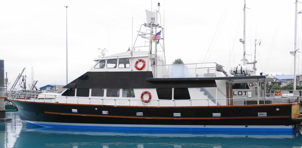
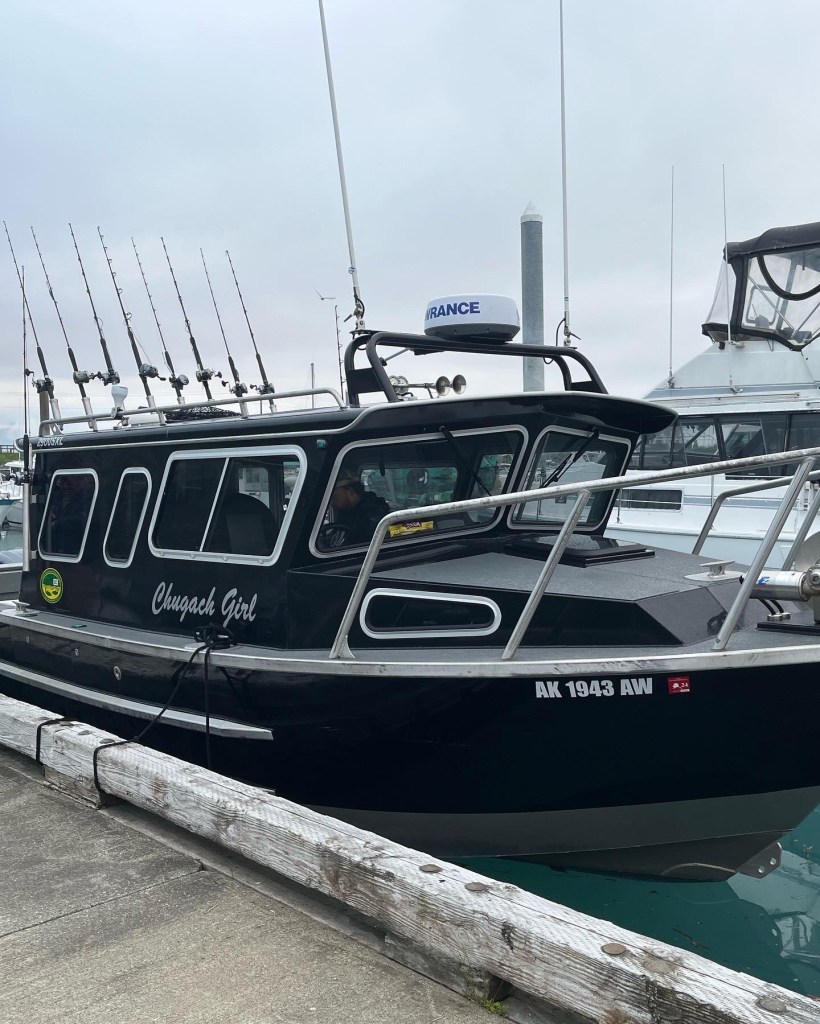
Dan and Al had their first of several Alaska fishing charters scheduled in Valdez, so we headed down to the marina to check out the docks the night before their charter.
Valdez marina
Here is the charter boat they went on, at 5:30 am
In Valdez, they have fish cleaning stations, with a ramp to discard the fish heads and skeletons. The remains go down into an area where they decompose and provide nutrients in the water. It also becomes an all you can eat buffet for the birds! It was the first time seeing an immature Bald Eagle. It takes five years for a Bald Eagle to fully develop their distinctive coloring.
The bird buffetImmature Bald Eagle
The guys took a halibut/rockfish charter, and had a successful day on the water catching their limit of halibut (2) and rockfish (4). They combined their catch and after processing, each ended up with twenty pounds of fillets. Rockfish are pretty tasty, but you don’t get very large fillets out of the fish. There were six people total on the charter, and here is their group photo. The halibut are hanging up, and the rockfish are on the ground.
The group catch
While the guys were away fishing, Karen and I decided to check out the local museum, which is currently in two separate locations. They are raising funds for a new museum, and based on the model, it looks like it will be a nice addition to the town. Hopefully they can break ground in the near future. The museums cover the history of Valdez, from the 1964 Earthquake, the building of the oil pipeline and the oil spill. I will do a separate post on the museum/history of Valdez.
LOCKED OUT!
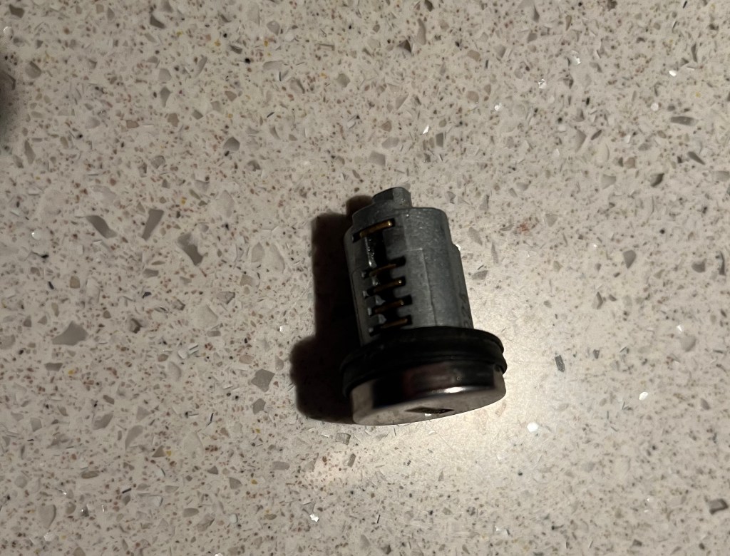
After Karen and I returned from the museum’s, I dropped off my camera, cell phone, keys and purse inside our motorhome, and took Makena out for a short walk. When I returned, I was unable to open the door to our motorhome. I was locked out!
Somehow, the door managed to lock itself. There are two locks on RV doors, the top one is a deadbolt, and the bottom one is the general lock. The deadbolt lock is usually unique to your specific RV, and the general lock is more generic, with many RV’s sharing the same lock. I looked around and went over to another Newmar motorhome owner who was sitting outside, and told him my situation. He came over with his set of keys, and we were able to determine it was the deadbolt that had locked itself. He said he read on forums that the door automatically locking itself has been a known problem on Newmar motorhomes, and said he always leaves a window unlocked – just in case. (we now do as well!!).
After we were unsuccessful in breaking in to our RV, I walked over by Karen’s and she looked up our Coachnet Roadside Assistance membership and found out it covers the cost of a locksmith if you get locked out of your RV or car! Yay! However, Al had their cell phone on their fishing trip, and their pre-paid phone did not work in Alaska. And my cell phone was locked inside our RV. I walked up to the office of our RV park and explained what happened to the owner, and asked if I could use their telephone to call our roadside assistance. With a wry smile, he reached down and handed me a hammer!
Despite it being a Sunday, about 20 minutes after I called Coachnet, they called me back at the RV office and said a locksmith was on his way. We were fortunate this happened in Valdez, which has one locksmith. It took about 10 minutes of work, but the deadbolt lock finally popped out, and the locksmith said it had broken in half, and was able to lock the door. It took another 10 minutes for him to still get the lock opened back up, as half of the lock remained in the door. The lock still works from the inside, so we are able to lock it at night, and when we travel.
The locksmith told me not to spend a lot of money replacing the lock, as any lock is easy to pick. We will look into fixing this over the winter when we are back in Yuma.
Half of the deadbolt lock
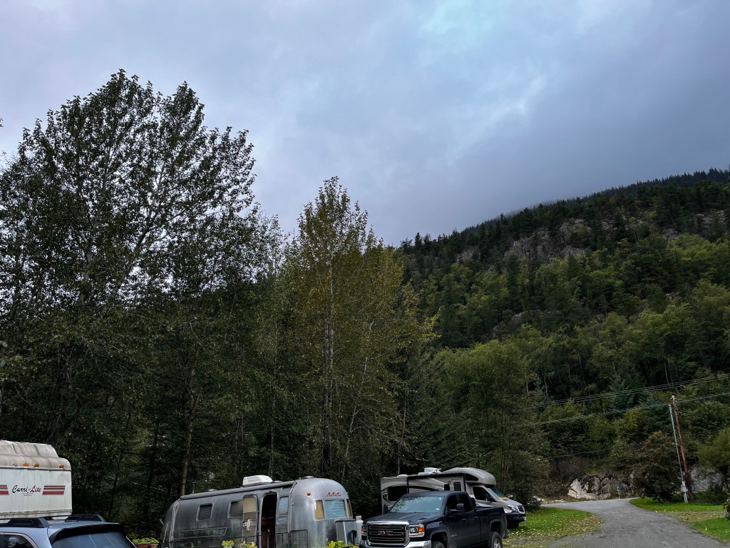
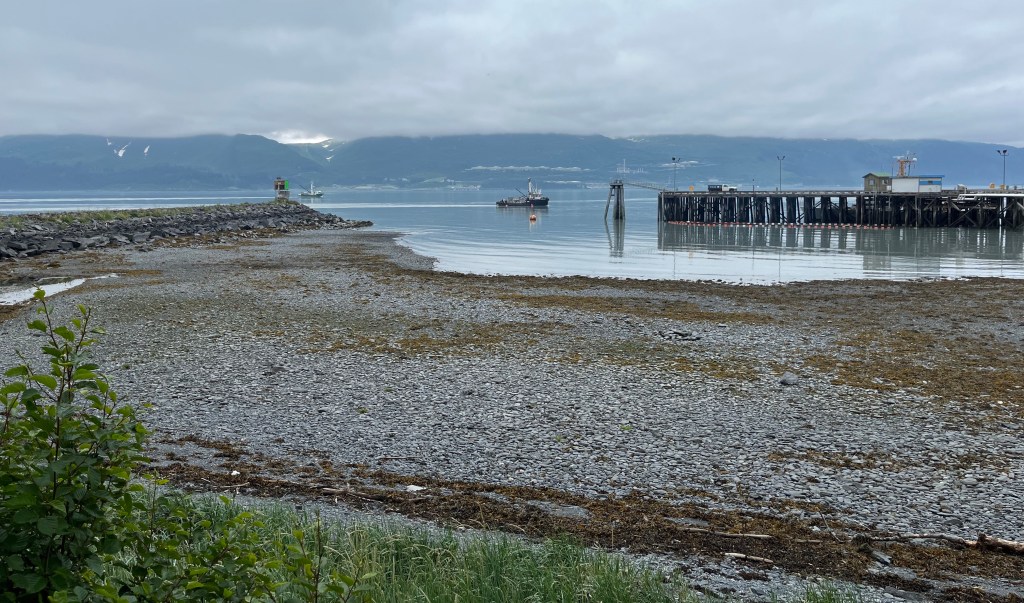
The RV spot we are in is right on the water, and it was fun watching the tide come in and out. In the mornings, the tide was out, and the cloud cover was in.
Tide out/clouds in
Late afternoon the clouds lifted, and the tide would come back in.
Tide in/clouds out
If you look off into the distance in the photo above, you can see what looks like some “white dash lines in the middle.” These are the tops of the storage containers for the terminus of the pipeline.
More to come on Valdez…
Quote of the day: “Fishing is quite a good metaphor for life. You do your prep, you do your thinking, you put your bait out, and you wait, confident that you’ve done your groundwork. But a lot of life is luck.” – Jeremy Wade
Located within Wrangell-St. Elias National Park (the largest national park in the United States) is Kennecott Mines National Historic Landmark. It was the top item on my personal list of things to see and do in Alaska, and it did not disappoint. Part of the allure of visiting this landmark is the challenge of getting to it.
McCarthy Road
And so it begins…
In order to reach the towns of McCarthy and Kennecott, you must first begin a 60 mile drive on an unpaved road that was originally used by the railroad servicing the mine. It is recommended to have a spare tire with you, as they are still uncovering railroad spikes in the gravel. You also need to be prepared for road washouts – they were repairing one section on the day we traveled. But it’s a beautiful and historic drive.
The road begins in the town of Chitina (pronounced “Chit-Na”) which was a major stop for the trains from Kennecott to the ships in the port city of Cordova. The log cabin below, constructed in 1910, is one of Chitina’s oldest buildings, and now serves as a National Park Service visitor center.
Historic log cabin
View of the Copper River along McCarthy Road.
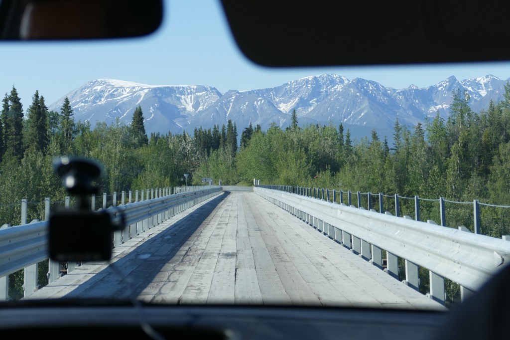
The Kuskulana River Bridge was built in 1910. This single-lane railroad bridge is 238 feet above the Kuskulana River.
My “back seat” view as we were driving across the one lane wooden bridge.
Twenty-nine miles into our trip on McCarthy Road we encounter the Gilahina Trestle, which was constructed in eight days during the winter of 1911. Over 15% of the railroad was built on wooden trestles like this, because of the rugged landscape. It’s really hard to believe it supported a train. It looks more like a Disney tower of terror train ride!
Once you reach the end of the 60 mile McCarthy Road, the journey is still not complete. Next up, you walk over a footbridge and wait for a shuttle bus to take you into the town of McCarthy. Or you can walk a half-mile from the footbridge into the town of McCarthy.
McCarthy is 4 1/2 miles downhill from Kennecott and was a supply and recreation spot for the mining town. The mining employees worked seven days a week, so they didn’t have much time to visit this little isolated town. Since we still had not made it to Kennecott, and had to wait for another shuttle bus to take us on the last 4 1/2 miles of our journey (with an elevation change of 3,000 feet) we did not have time to check out the little shops. It looked like a fun little town.
Town of McCarthy
Three and a half hours after we began our journey, we arrived in Kennecott!
History of Kennecott Mines
As gold prospectors started exploring the area, a young mining engineer, Stephen Birch, joined expeditions in 1898 and 1899. In 1900, prospectors Clarence Warner and Jack Smith discovered the Bonanza Ridge and staked copper claims in this area. Given the remoteness of the area, a lot of money was needed to mine in this area. Stephen Birch sought out financial backing from the Havermeyer, Guggenheim and J.P. Morgan families and formed the Kennecott Copper Corporation. The town of Kennecott was established and grew along with the mining and mill operations.
A total of four underground mines were developed and operated twenty four hours a day, seven days a week until the operation closed in 1938 due to declining concentrations of ore, along with declining prices for the ore. It was no longer profitable to continue mining here. Over 4.6 million tons of ore was extracted from the mines producing almost $300 million dollars worth of copper and silver (and a profit of over $100 million for the Corporation). The mines are not available for touring, and the entrances to them have been filled with concrete to keep people out.
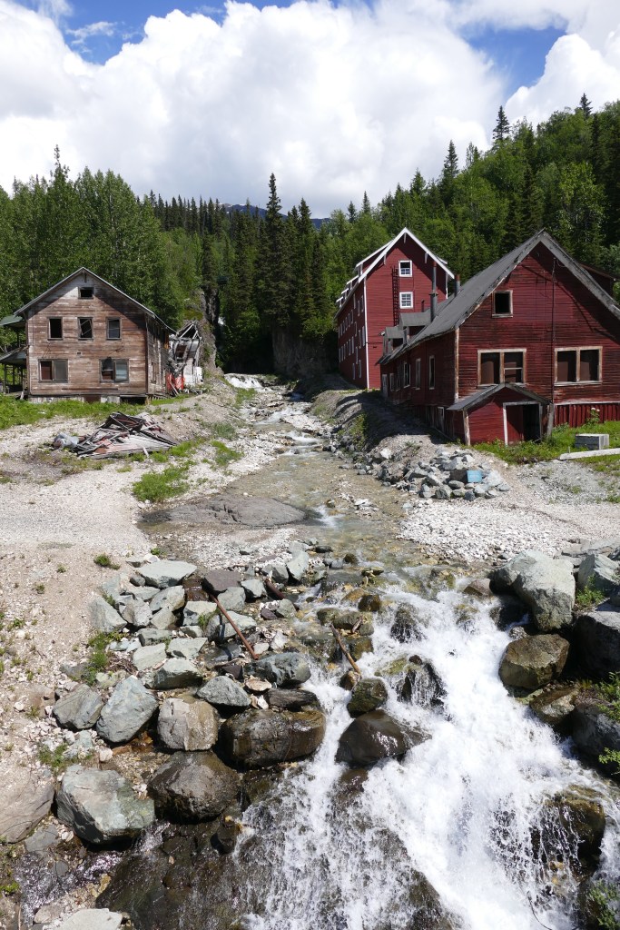
The town is perched right above the Kennicott Glacier and the Root Glacier. (Yes, the glacier and the town have two different spellings – one with an ‘i’ and the town with an ‘e’). It makes for a beautiful setting. In the photo below, the Root Glacier remains snow covered in the background. The Kennicott Glacier’s ice is covered by rocks and dirt, called a moraine.
Kennicott Glacier left, Root Glacier back right
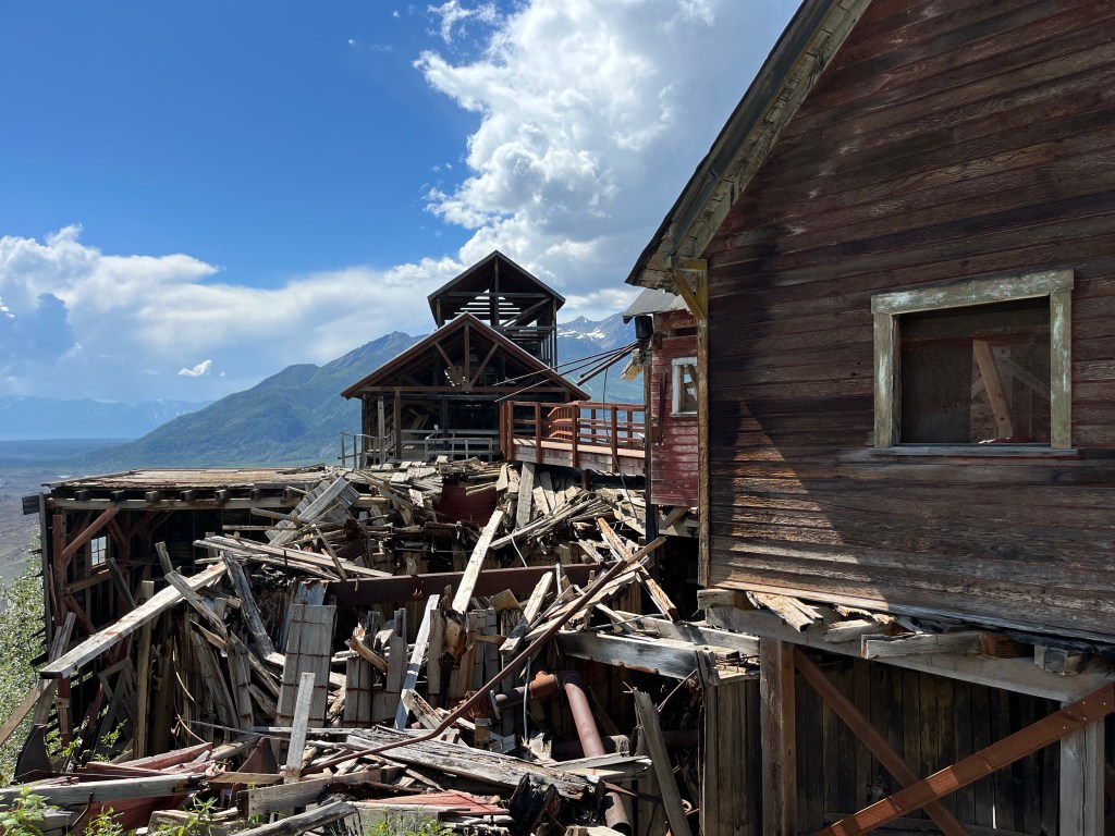
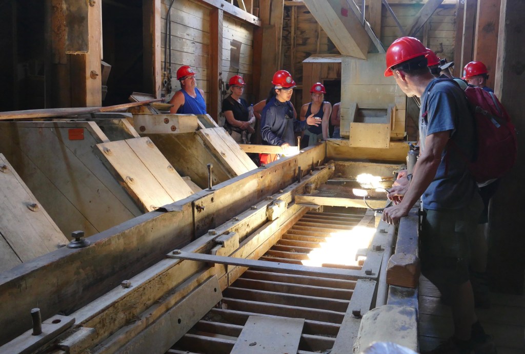
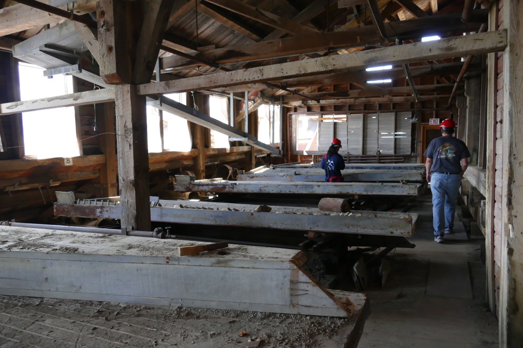
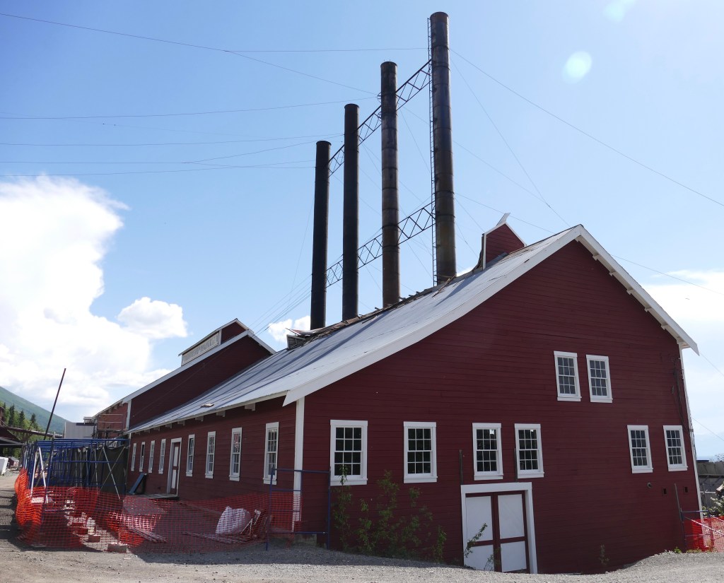
The 14 story Concentration Mill is the highlight of the Kennecott Mines Historic Landmark. The mill underwent many changes over a twenty year period as new techniques were developed in processing the ore. This is why the building looks like a hodge-podge of buildings put together. The train cars would pull right into the building in the center for loading of the processed ore.
A view from the other side of the mill has a better view of the different structures that were added on.
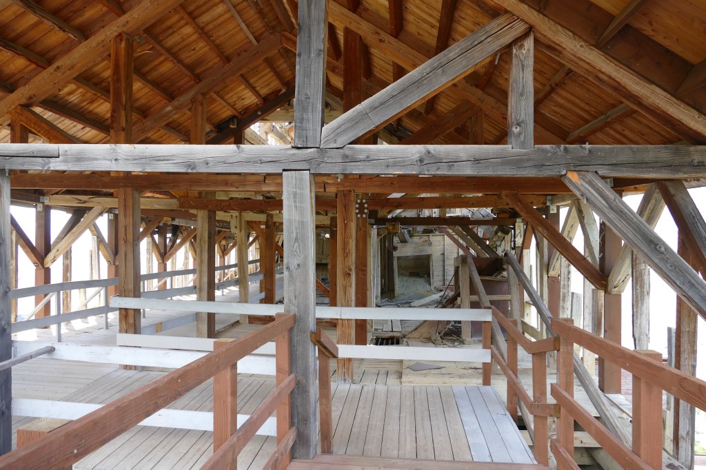
The only way to see the inside of the building is on a guided tour (cost $28.00 – totally worth it!). Unless of course you have an issue with heights, as you start the tour on top, and descend down all 14 stories of the building on steep steps and ladders that have been added by the park service, since some areas are no longer safe.
A short walk up a path alongside the mill takes you to the stop, and the start of the tour. There are amazing views of the area. This is the view to the right, of the Kennicott Glacier (what looks like piles of dirt) and part of the town including the power plant (4 smokestacks).
Another view of the Kennicott Glacier and the top buildings of the mill.
Views to the left show some of the restored building in the town, along with the Kennicott Glacier (again this is not piles of dirt from the mine, it is the moraine, covering up ice).
Entry way into the mine
The building just beyond the entry way has collapsed.
But the park service has built a walkway to connect to the next building.
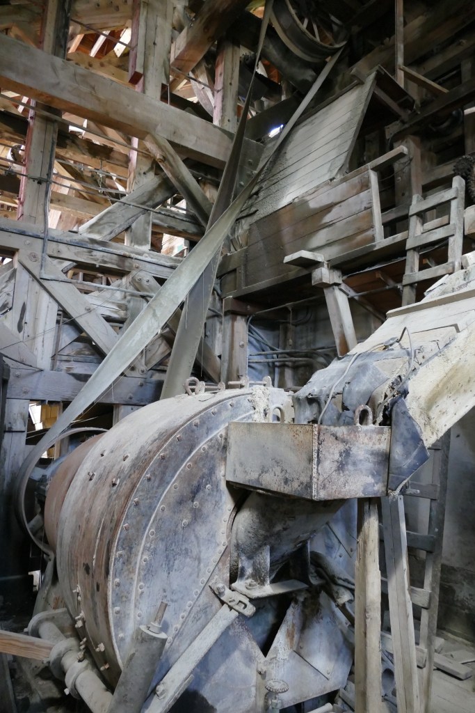
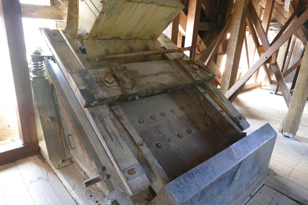
The ore and rock were delivered to the mill from the mines via a tramway. The mill was able to process 1200 tons of ore per day. It was cheaper to process the ore here, before shipping it down to Tacoma, Washington for final processing. The ore went through a series of crushers and sorters before being placed in burlap bags and put on the train.
Crushing machine
Several different styles of sorting machines were used.
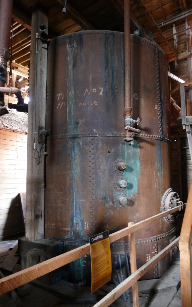
In order to maximize the profitability of the mine, low grade ore was put into tanks of ammonia which dissolved the copper in the ore. That solution was placed in another tank which was heated so the remaining ammonia evaporated off. The ammonia tanks have been preserved.
The power plant was not open for tour, as the roof collapsed over the winter from a heavy snowfall. The park service is working on restoring the building.
Power Plant
Several bunkhouses were built to house the men working for the mine. They had to pay $1.25 for room and board, which included meals. A school was also built, which not only provided education for the children, but adults as well. In 1920, the school educated 126 adult students from 23 countries that were working at the mill. The corporation taught English and helped the employees study for their citizenship.
Bunkhouse and School buildings
While the employees had shared quarters, the managers were able to live in small cottages with their family. They paid about 25% of their wages to live in them. Several of the remaining cottages are privately owned residences (purchased before the park service took over operation of the town in 1998). They have one that has been restored and open to the public.
Interior of the cottage
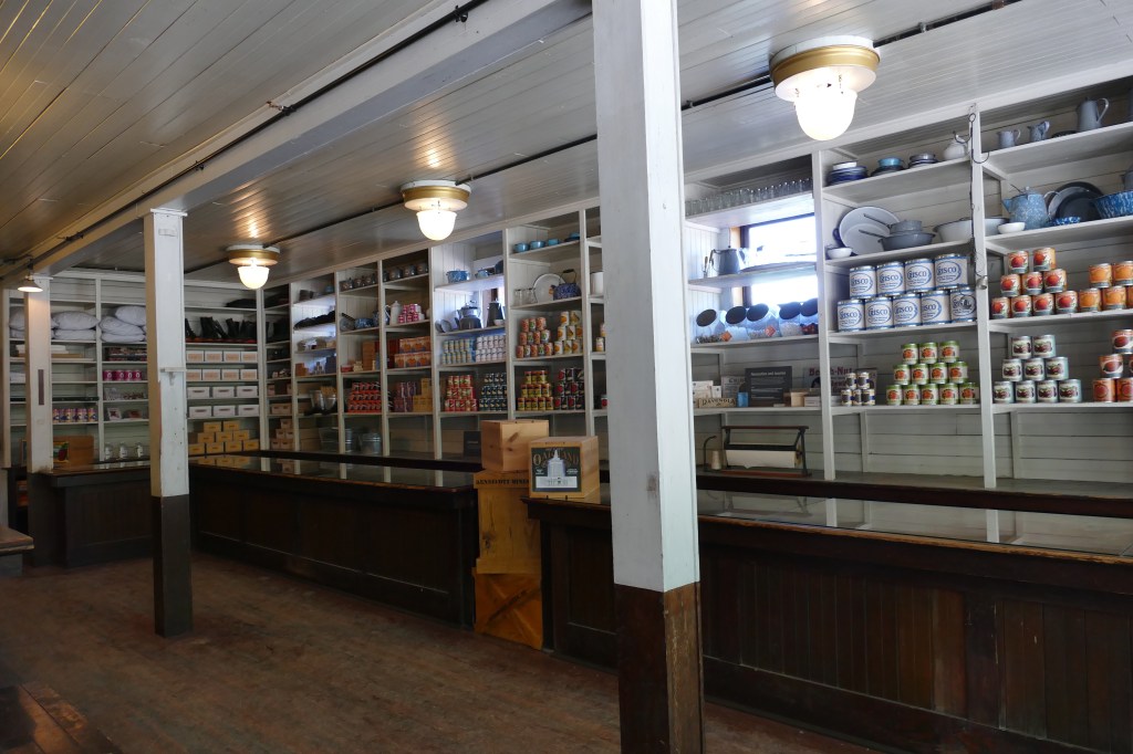
The town had it’s own Post Office and General Store for the employees.
In 1915, a hospital was built which was not only used by the mill employees, but members of surrounding communities. The first X-ray machine in Alaska was used at this hospital. Once a month a dentist would arrive for check-ups. Employees had eight cents per day deducted from their checks for medical/dental coverage.
The hospital is on the left and two bunkhouses for employees are on the right. The buildings were damaged from a flood several years ago.
An additional view of the town, with the train station on the lower right, and a glimpse of the Root Glacier in the background on the left.
Town of Kennecott
And finally, this is what started it all…
It was a long day touring this historic landmark, but definitely worth the challenge of getting there.
Quote of the Day: “The meek shall inherit the Earth, but not it’s mineral rights.” – J. Paul Getty