Another month has gone by, and our vacation time in Alaska will soon be coming to an end. I am woefully behind on blogging, and I promise to catch up. But given the choice between playing tourist, and sitting at a computer with mediocre internet, guess what wins! And by the end of the day I just have little motivation. But I am always current on Instagram.
It’s easy to do posts like this, because I don’t have to sort through and add photos. So here is our monthly tally on expenses.
GAS
Since we had less driving and longer campground stays, gas was a reasonable $653.05 for the month, with prices ranging from $5.549/gallon down to $4.799/gallon. Prices continue to decline, and have dropped over $1/gallon since we arrived in Alaska.
CAMPGROUND COSTS
Campground costs were a budget buster in July, because we were staying for longer days in popular fishing towns, during peak fishing season. For 31 nights, we spent $1,586.56, at a daily cost of $51.18/night. Are there cheaper options – yes. And there are many places to boondock (camping without hookups).
ENTERTAINMENT
We spent $475.93 on museums, a sea life center and an excellent boat trip. As with last month, I am not including fishing costs in with entertainment. I will do that at the end.
INSTAGRAM POSTS
As you can see from the posts below, there have been a lot of successful fishing trips!
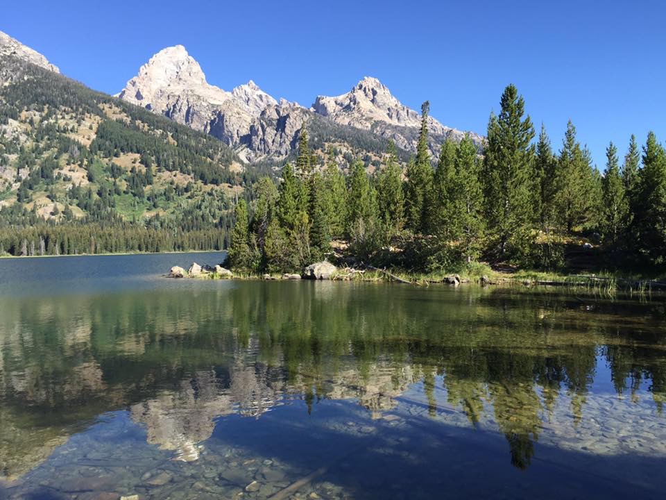
After our short stay in Chitina to visit the Kennecott Mill, we headed south to the small coastal town of Valdez. But first, a moose sighting while we were in Chitina!
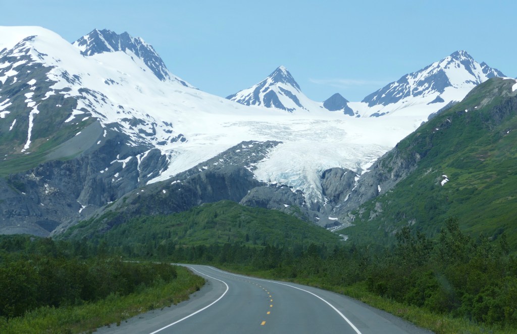
I wasn’t sure what to expect from the town of Valdez as I have only associated it with the Exxon Valdez oil spill back on March 24, 1989. As we were approaching the town, I was struck by how beautiful the surrounding area is, including our first look at the Worthington Glacier, one of many glaciers in Alaska. This one is visible right from the road.
This little coastal town of 3800 people has been our favorite town so far. It just has a unique positive vibe to it, and if you are planning on visiting Alaska, make sure you spend at least five days here. We could have actually used a few more days. The city receives the most snow in Alaska, an average of 305 inches per year. That’s 25 feet of snow, which is probably why their welcome sign is so tall!
FISHING
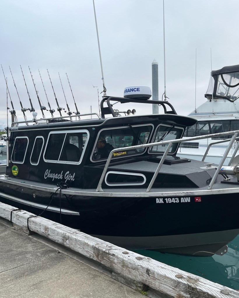
Dan and Al had their first of several Alaska fishing charters scheduled in Valdez, so we headed down to the marina to check out the docks the night before their charter.
Valdez marina
Here is the charter boat they went on, at 5:30 am
In Valdez, they have fish cleaning stations, with a ramp to discard the fish heads and skeletons. The remains go down into an area where they decompose and provide nutrients in the water. It also becomes an all you can eat buffet for the birds! It was the first time seeing an immature Bald Eagle. It takes five years for a Bald Eagle to fully develop their distinctive coloring.
The bird buffetImmature Bald Eagle
The guys took a halibut/rockfish charter, and had a successful day on the water catching their limit of halibut (2) and rockfish (4). They combined their catch and after processing, each ended up with twenty pounds of fillets. Rockfish are pretty tasty, but you don’t get very large fillets out of the fish. There were six people total on the charter, and here is their group photo. The halibut are hanging up, and the rockfish are on the ground.
The group catch
While the guys were away fishing, Karen and I decided to check out the local museum, which is currently in two separate locations. They are raising funds for a new museum, and based on the model, it looks like it will be a nice addition to the town. Hopefully they can break ground in the near future. The museums cover the history of Valdez, from the 1964 Earthquake, the building of the oil pipeline and the oil spill. I will do a separate post on the museum/history of Valdez.
LOCKED OUT!
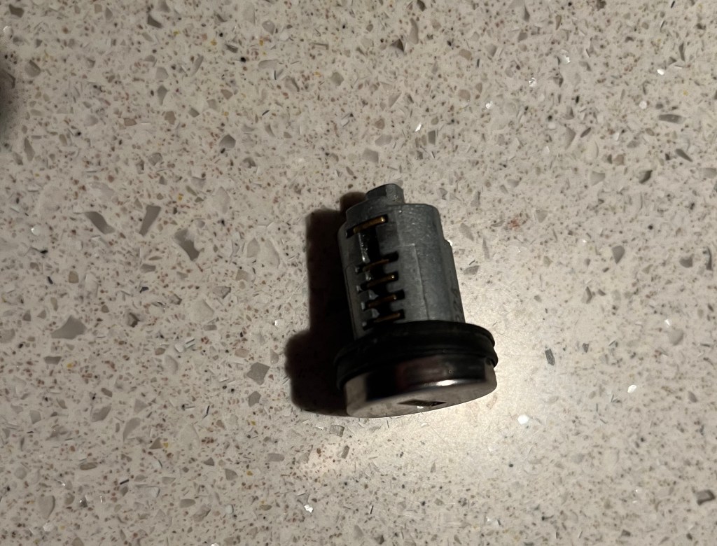
After Karen and I returned from the museum’s, I dropped off my camera, cell phone, keys and purse inside our motorhome, and took Makena out for a short walk. When I returned, I was unable to open the door to our motorhome. I was locked out!
Somehow, the door managed to lock itself. There are two locks on RV doors, the top one is a deadbolt, and the bottom one is the general lock. The deadbolt lock is usually unique to your specific RV, and the general lock is more generic, with many RV’s sharing the same lock. I looked around and went over to another Newmar motorhome owner who was sitting outside, and told him my situation. He came over with his set of keys, and we were able to determine it was the deadbolt that had locked itself. He said he read on forums that the door automatically locking itself has been a known problem on Newmar motorhomes, and said he always leaves a window unlocked – just in case. (we now do as well!!).
After we were unsuccessful in breaking in to our RV, I walked over by Karen’s and she looked up our Coachnet Roadside Assistance membership and found out it covers the cost of a locksmith if you get locked out of your RV or car! Yay! However, Al had their cell phone on their fishing trip, and their pre-paid phone did not work in Alaska. And my cell phone was locked inside our RV. I walked up to the office of our RV park and explained what happened to the owner, and asked if I could use their telephone to call our roadside assistance. With a wry smile, he reached down and handed me a hammer!
Despite it being a Sunday, about 20 minutes after I called Coachnet, they called me back at the RV office and said a locksmith was on his way. We were fortunate this happened in Valdez, which has one locksmith. It took about 10 minutes of work, but the deadbolt lock finally popped out, and the locksmith said it had broken in half, and was able to lock the door. It took another 10 minutes for him to still get the lock opened back up, as half of the lock remained in the door. The lock still works from the inside, so we are able to lock it at night, and when we travel.
The locksmith told me not to spend a lot of money replacing the lock, as any lock is easy to pick. We will look into fixing this over the winter when we are back in Yuma.
Half of the deadbolt lock
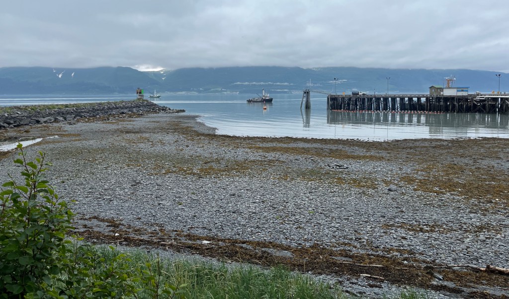
The RV spot we are in is right on the water, and it was fun watching the tide come in and out. In the mornings, the tide was out, and the cloud cover was in.
Tide out/clouds in
Late afternoon the clouds lifted, and the tide would come back in.
Tide in/clouds out
If you look off into the distance in the photo above, you can see what looks like some “white dash lines in the middle.” These are the tops of the storage containers for the terminus of the pipeline.
More to come on Valdez…
Quote of the day: “Fishing is quite a good metaphor for life. You do your prep, you do your thinking, you put your bait out, and you wait, confident that you’ve done your groundwork. But a lot of life is luck.” – Jeremy Wade
Located within Wrangell-St. Elias National Park (the largest national park in the United States) is Kennecott Mines National Historic Landmark. It was the top item on my personal list of things to see and do in Alaska, and it did not disappoint. Part of the allure of visiting this landmark is the challenge of getting to it.
McCarthy Road
And so it begins…
In order to reach the towns of McCarthy and Kennecott, you must first begin a 60 mile drive on an unpaved road that was originally used by the railroad servicing the mine. It is recommended to have a spare tire with you, as they are still uncovering railroad spikes in the gravel. You also need to be prepared for road washouts – they were repairing one section on the day we traveled. But it’s a beautiful and historic drive.
The road begins in the town of Chitina (pronounced “Chit-Na”) which was a major stop for the trains from Kennecott to the ships in the port city of Cordova. The log cabin below, constructed in 1910, is one of Chitina’s oldest buildings, and now serves as a National Park Service visitor center.
Historic log cabin
View of the Copper River along McCarthy Road.
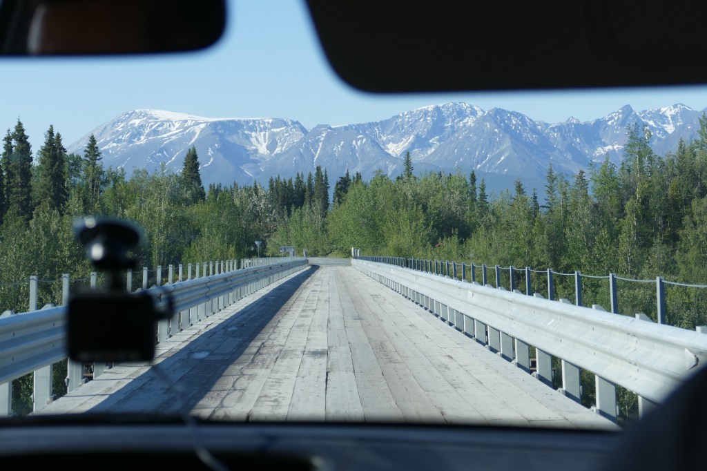
The Kuskulana River Bridge was built in 1910. This single-lane railroad bridge is 238 feet above the Kuskulana River.
My “back seat” view as we were driving across the one lane wooden bridge.
Twenty-nine miles into our trip on McCarthy Road we encounter the Gilahina Trestle, which was constructed in eight days during the winter of 1911. Over 15% of the railroad was built on wooden trestles like this, because of the rugged landscape. It’s really hard to believe it supported a train. It looks more like a Disney tower of terror train ride!
Once you reach the end of the 60 mile McCarthy Road, the journey is still not complete. Next up, you walk over a footbridge and wait for a shuttle bus to take you into the town of McCarthy. Or you can walk a half-mile from the footbridge into the town of McCarthy.
McCarthy is 4 1/2 miles downhill from Kennecott and was a supply and recreation spot for the mining town. The mining employees worked seven days a week, so they didn’t have much time to visit this little isolated town. Since we still had not made it to Kennecott, and had to wait for another shuttle bus to take us on the last 4 1/2 miles of our journey (with an elevation change of 3,000 feet) we did not have time to check out the little shops. It looked like a fun little town.
Town of McCarthy
Three and a half hours after we began our journey, we arrived in Kennecott!
History of Kennecott Mines
As gold prospectors started exploring the area, a young mining engineer, Stephen Birch, joined expeditions in 1898 and 1899. In 1900, prospectors Clarence Warner and Jack Smith discovered the Bonanza Ridge and staked copper claims in this area. Given the remoteness of the area, a lot of money was needed to mine in this area. Stephen Birch sought out financial backing from the Havermeyer, Guggenheim and J.P. Morgan families and formed the Kennecott Copper Corporation. The town of Kennecott was established and grew along with the mining and mill operations.
A total of four underground mines were developed and operated twenty four hours a day, seven days a week until the operation closed in 1938 due to declining concentrations of ore, along with declining prices for the ore. It was no longer profitable to continue mining here. Over 4.6 million tons of ore was extracted from the mines producing almost $300 million dollars worth of copper and silver (and a profit of over $100 million for the Corporation). The mines are not available for touring, and the entrances to them have been filled with concrete to keep people out.
The town is perched right above the Kennicott Glacier and the Root Glacier. (Yes, the glacier and the town have two different spellings – one with an ‘i’ and the town with an ‘e’). It makes for a beautiful setting. In the photo below, the Root Glacier remains snow covered in the background. The Kennicott Glacier’s ice is covered by rocks and dirt, called a moraine.
Kennicott Glacier left, Root Glacier back right
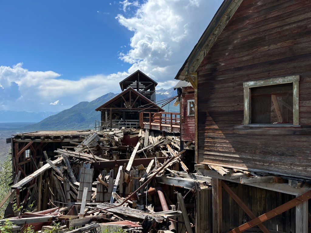
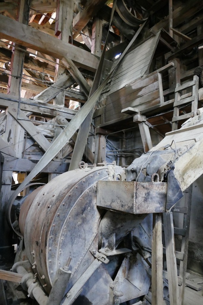
The 14 story Concentration Mill is the highlight of the Kennecott Mines Historic Landmark. The mill underwent many changes over a twenty year period as new techniques were developed in processing the ore. This is why the building looks like a hodge-podge of buildings put together. The train cars would pull right into the building in the center for loading of the processed ore.
A view from the other side of the mill has a better view of the different structures that were added on.
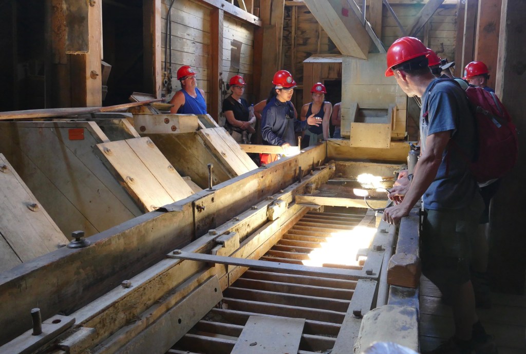
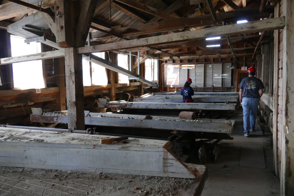
The only way to see the inside of the building is on a guided tour (cost $28.00 – totally worth it!). Unless of course you have an issue with heights, as you start the tour on top, and descend down all 14 stories of the building on steep steps and ladders that have been added by the park service, since some areas are no longer safe.
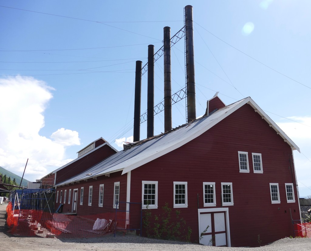
A short walk up a path alongside the mill takes you to the stop, and the start of the tour. There are amazing views of the area. This is the view to the right, of the Kennicott Glacier (what looks like piles of dirt) and part of the town including the power plant (4 smokestacks).
Another view of the Kennicott Glacier and the top buildings of the mill.
Views to the left show some of the restored building in the town, along with the Kennicott Glacier (again this is not piles of dirt from the mine, it is the moraine, covering up ice).
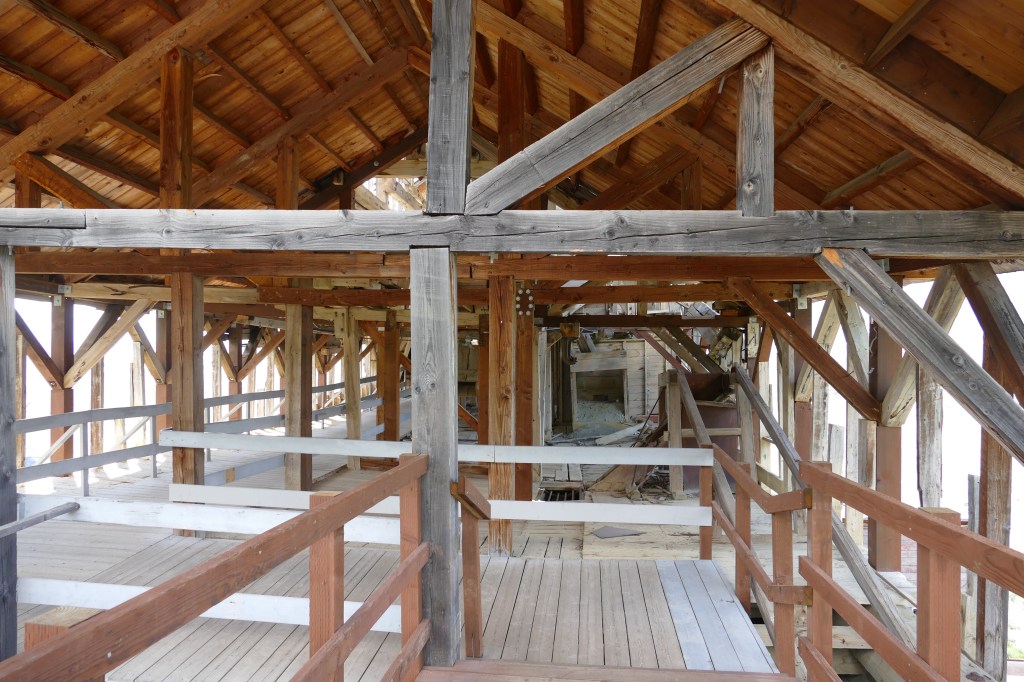
Entry way into the mine
The building just beyond the entry way has collapsed.
But the park service has built a walkway to connect to the next building.
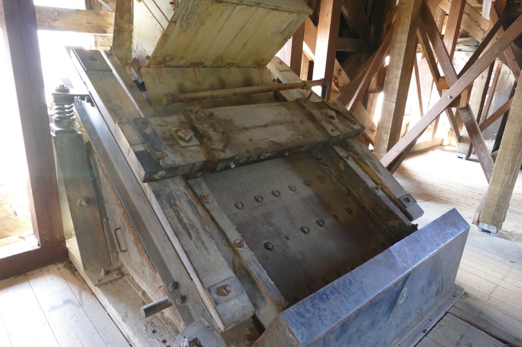
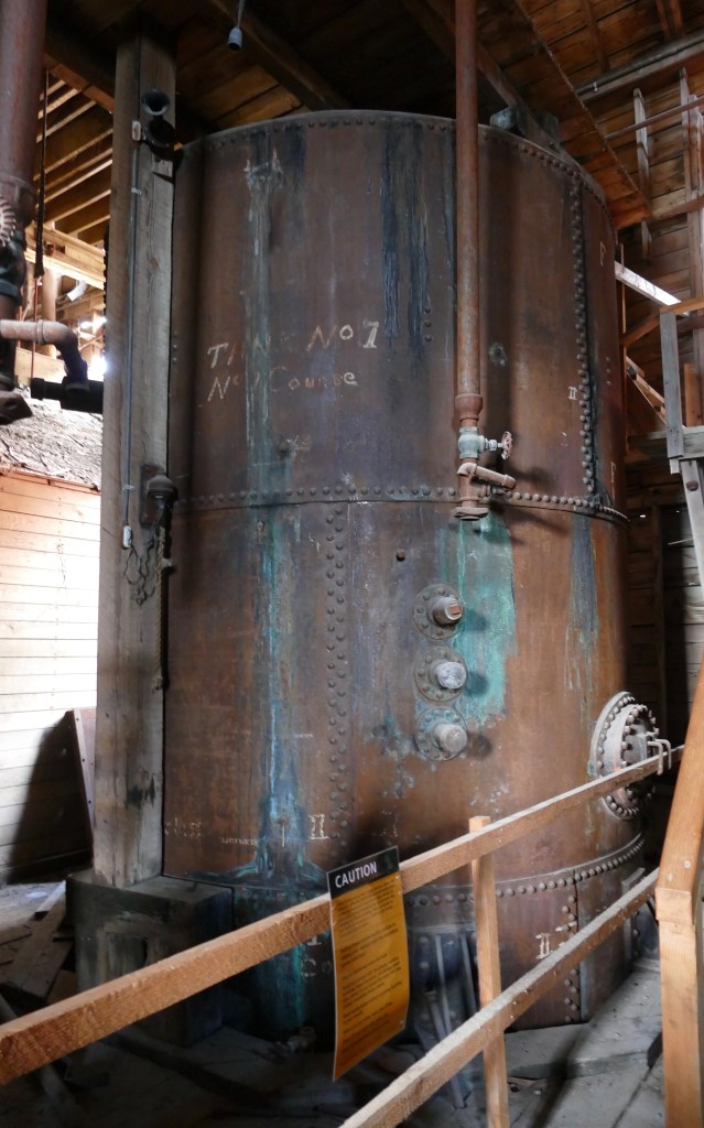
The ore and rock were delivered to the mill from the mines via a tramway. The mill was able to process 1200 tons of ore per day. It was cheaper to process the ore here, before shipping it down to Tacoma, Washington for final processing. The ore went through a series of crushers and sorters before being placed in burlap bags and put on the train.
Crushing machine
Several different styles of sorting machines were used.
In order to maximize the profitability of the mine, low grade ore was put into tanks of ammonia which dissolved the copper in the ore. That solution was placed in another tank which was heated so the remaining ammonia evaporated off. The ammonia tanks have been preserved.
The power plant was not open for tour, as the roof collapsed over the winter from a heavy snowfall. The park service is working on restoring the building.
Power Plant
Several bunkhouses were built to house the men working for the mine. They had to pay $1.25 for room and board, which included meals. A school was also built, which not only provided education for the children, but adults as well. In 1920, the school educated 126 adult students from 23 countries that were working at the mill. The corporation taught English and helped the employees study for their citizenship.
Bunkhouse and School buildings
While the employees had shared quarters, the managers were able to live in small cottages with their family. They paid about 25% of their wages to live in them. Several of the remaining cottages are privately owned residences (purchased before the park service took over operation of the town in 1998). They have one that has been restored and open to the public.
Interior of the cottage
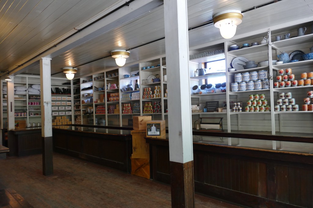
The town had it’s own Post Office and General Store for the employees.
In 1915, a hospital was built which was not only used by the mill employees, but members of surrounding communities. The first X-ray machine in Alaska was used at this hospital. Once a month a dentist would arrive for check-ups. Employees had eight cents per day deducted from their checks for medical/dental coverage.
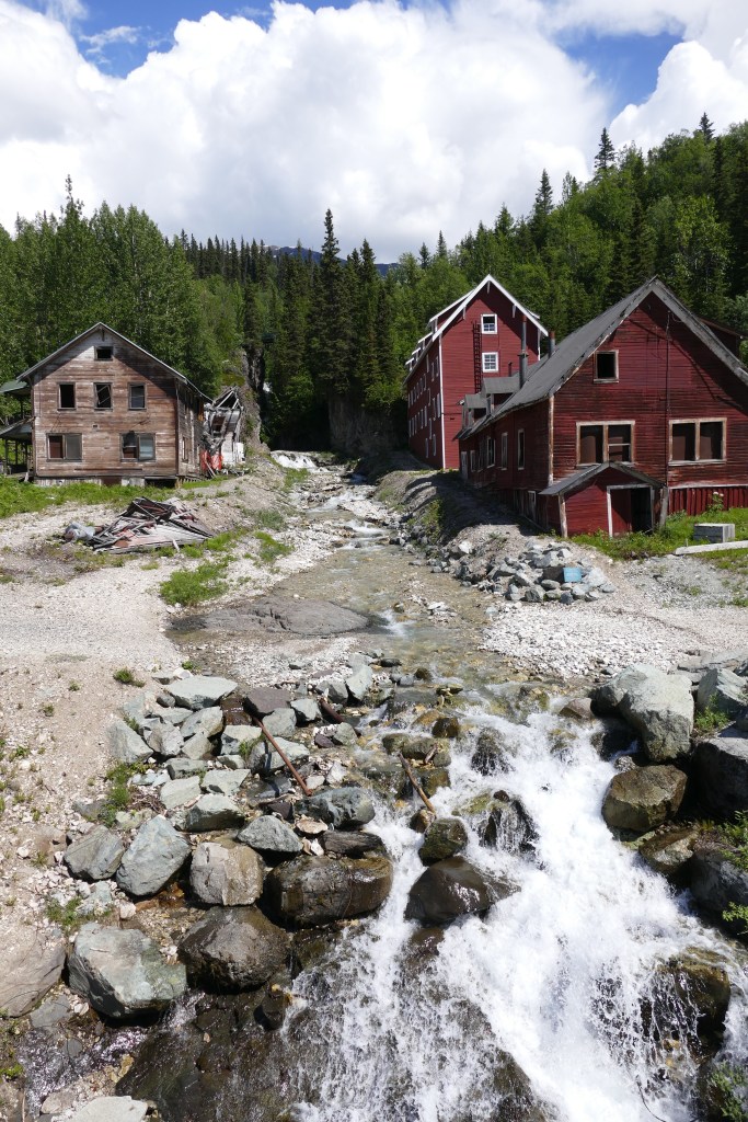
The hospital is on the left and two bunkhouses for employees are on the right. The buildings were damaged from a flood several years ago.
An additional view of the town, with the train station on the lower right, and a glimpse of the Root Glacier in the background on the left.
Town of Kennecott
And finally, this is what started it all…
It was a long day touring this historic landmark, but definitely worth the challenge of getting there.
Quote of the Day: “The meek shall inherit the Earth, but not it’s mineral rights.” – J. Paul Getty
As I did with May, I will post our expenses for the month of June for gas, campgrounds and entertainment. I have decided not to include fishing in with our entertainment costs, and will post those expenses when I do a final summary of our trip costs when we are back in the lower 48.
GAS
We drove a total of 1,708 miles in June on our motorhome. Gas prices in British Columbia and the Yukon are significantly higher than Alberta. We paid between 2.077/liter and 2.349/liter, which comes to $7.86/gallon Canadian (or $6.13 American) and $8.89/gallon Canadian (or $6.94 American).
Gas prices in Alaska have ranged from $5.24 to $5.859. And they have been coming down since we crossed into Alaska on June 18th. Our total cost for gas for the month of June was $1,403.05. For July, we will be staying longer in various cities, instead of driving every one to three days. So that should cut down gas costs for July. I am also keeping track of gas costs for our Honda CRV that we are towing, and will put that in our final expense summary.
CAMPGROUNDS
Although we didn’t like Canadian fuel prices, they were offset by cheaper campgrounds than Alaska. For our 30 nights in June, we paid a total of $1200.73 for campgrounds, for a cost of $40.02 per night. Sounds expensive, but still cheaper than a hotel! The campgrounds in Alaska have a short season – basically June 1 to September 1 is their main window of business.
ENTERTAINMENT
Our total expenses for sightseeing tours and museums was $443.46. The biggest chunk was $340.00 for our glacier boat tour on the LuLu Belle in Valdez, Alaska for the two of us, including a fuel surcharge that everyone seems to be adding. It was a wonderful cruise and I highly recommend it. (future blog post coming on that)
And speaking of blogging, I have been thinking about what I want to do with the blog. I’m about three weeks behind posting. I thought about just doing a weekly summary of our travels and put in lots of photos, but I have decided against that. Using Instagram has allowed me to do a short current update, so people know where we are.
I will continue to plug away on the blog, and do more detailed posts. Many people have texted or e-mailed that they like the information. Others just like the photos! I would need a full day just to go through photos and write posts to get all caught up, but I’m more interested in playing tourist! I will get to blogging when I can.
INSTAGRAM POSTS JUNE 16 – JUNE 30
if you get the blog by e-mail, and the Instagram posts just show up as square stating ”open in Instagram,” you can go to our website, liv2rv.com and view the posts without having to go on Instagram.
Hello everyone, it’s your favorite dog blogger, Makena! Giving you an update on my Alaskan/Canadian adventures!
Keeping my peeps informed
I eat both dry and canned dog food. The dry food is out anytime I want, and my parents are great about keeping my dish full at all times. They even fill a small treat ball with my food and milk bones for me to play with and snack on whenever I want.
But it’s my 5:00 pm canned food time that I really look forward to. Around 4:00 pm is when I casually start reminding my parents that its getting close. And at 4:30 I start sitting in the kitchen, just so I don’t miss it. At 4:45 I may bark a few times, as it’s getting really close to 5 pm.
What I don’t understand is these crazy time zone changes. What do you mean it’s no longer 5 pm? Yesterday it was 5 pm. Why is is now 4 pm? And why does this keep changing?
We spend all winter in Arizona, and the time never changes. It’s a very “dog friendly” state if you ask me. We leave Arizona, and the time changes…something about “Daylight Savings Time.” Then it’s “Pacific Daylight Time” in Nevada. Back to Mountain Daylight Savings time in Alberta.
British Columbia goes on Pacific Time, so I lost my hour again. What’s a dog to do?
Then we cross into the Yukon province, and it stays on Mountain Standard Time all year. Even though it is right above British Columbia. Are you as confused as I am?!
And then there’s Alaska – my parents told me it will be another time zone change. Sheesh!
I’m also getting a little perplexed about all this daylight. When my mom gets up, it’s already pretty bright outside. So when she takes me out, I’m thinking she must have overslept or something. It feels like the middle of the day. When my dad takes me out before I go to bed, it’s still daylight out – shouldn’t we be staying up? Where’s the darkness? It just gets “less bright” now, there hasn’t really been any darkness.
The other morning the sunshine was peeking through the shades and I woke my mom up, as I thought she may have overslept. She mumbled something about it being only 4 am, but I persisted, so she took me out. I had the campground all to myself! No other dog in sight! The next day, or morning, or whatever, I tried to do it again. This time my mom just threw the covers over me, so it was dark again, and I went back to sleep!
VISITING MY YUMA PALS IN ALASKA
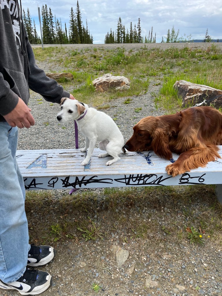
I did take a side trip with my parents from Teslin, Yukon to Skagway, Alaska to visit my pals Finnigan and Duffy. I see them all the time in Yuma. Their parents, Tom and Ellen, are working in Skagway for the summer. The border agents for both the United States and Canada asked nothing about me. They just peeked in the back seat of our car and looked at me, sound asleep in my kennel.
Duffy was super excited to see me, jumping for joy! He loves visitors!
Yay, it’s Makena!
I, of course, was less than excited to see a giant dog leaping towards me. I turned around and headed back to the car.
Nope
Eventually, he settled down, and we said our greetings.
Finnegan, me and Duffy
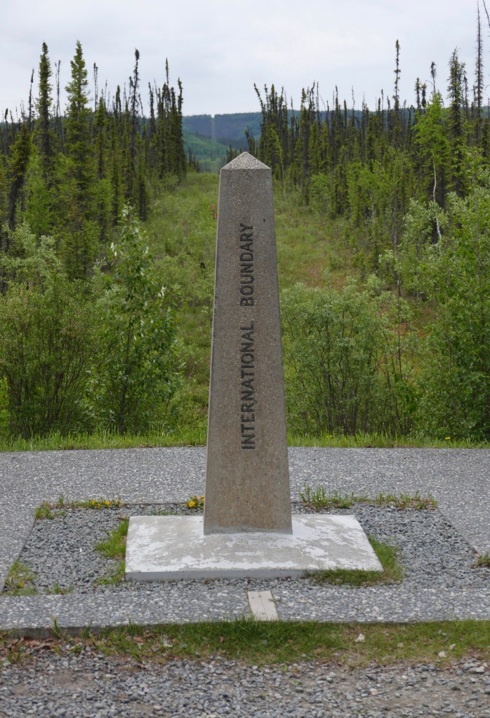
An International Incident?
We have finally made it to Alaska – it’s really a long, bumpy drive. My parents put in some extra padding in my kennel, but the last day of driving I was getting bounced around a lot. I did pose for some photos at the border. There is a bench right on the boundary line that I was sitting on.
Alaska/Yukon border
I put my front paws in the US, and back paws in Canada. My buddy Cody snuck up behind me and stuck his cold nose where it doesn’t belong – I believe this has to violate some international law or something!
An international crime?
I’ve been enjoying our travels so far, even if it has been a bit confusing for me. So many new smells, and new dogs to see from a safe distance. I’ll keep you posted! Take care and stay safe everyone!
Quote of the Day: “The reason a dog has so many friends is that he wags his tail instead of his tongue.” – Unknown
Alaska 2020. Alaska 2021. Alaska 2022!! Third times a charm!
June 18, 2022
I guess we should have brought a sticker to attach to the back of the sign. For those from the Milwaukee, Wisconsin area, you will probably be familiar with the sticker in the middle of the sign!
A small marker identifies the official boundary.
Which means a photo opportunity – standing in two countries!
Does Canada and the United States take turns cutting the grass on the boundary line?
For those crossing the border into Alaska in a recreation vehicle, be aware that the RV lane has a maximum height clearance of 12 feet, 10 inches. We are exactly 12’ 10”, so we went into the commercial truck lane, which does not have a roof. The border agent had no problem with this, and said he doesn’t want people taking out their sprinkler system! I’m really surprised by this height restriction, given that many RV’s, particularly 5th wheels, are over 13 feet. Due to posted restrictions, I did not take a photograph any closer to the border station.
To the left of the large yellow pole in the photo below, you can see there is a Tiffin gas motorhome in the RV lane. They must not have seen the sign, or did not know how tall they were. We could hear the agents directing them to proceed as slowly as possible through the entrance llane, so they would not damage anything. The truck entrance is not visible in the photo, but is on the far right.
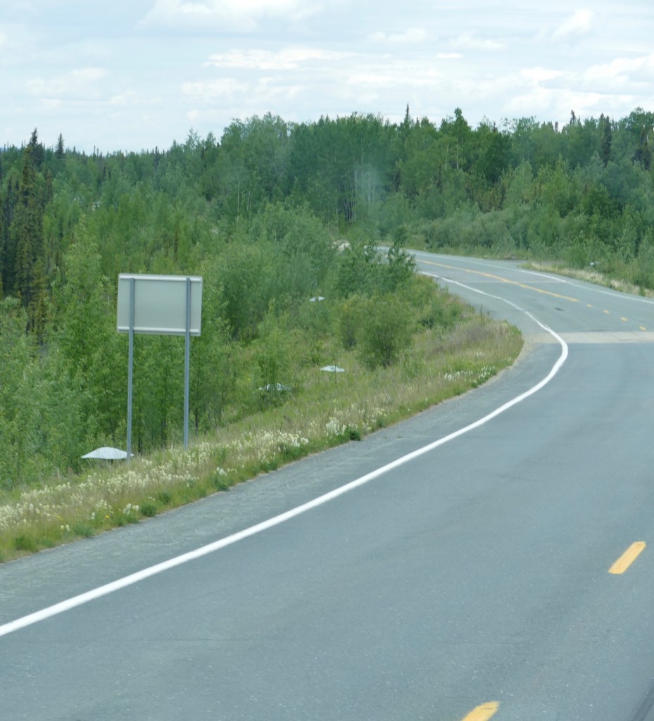
The last stretch of road in the Yukon was the worst section, and that continued on for about 40 miles into the US before we arrived at Tok, Alaska for the night. Due to the permafrost in this area, the road is full of potholes and frost heaves. As temperatures increase, the road conditions decrease, as the ground underneath is moving. It’s a never ending job for the road construction crews.
According to the history of the Alaska Highway, this section of road, which was completed in 1942, completely disappeared in the spring of 1943, and had to be rebuilt.
Over the years both governments have experimented with various methods to build a successful road on the permafrost. On the left side of the highway in the photos below you may see little white markings. These are three foot high vertical metal culverts with “hats”. They were used as an experiment to keep the ground from thawing, which is what causes the frost heaves. They did not work.
This is a close-up that I took as we were driving past.
The “hats”
In the two photos below, is the current “Alaska Highway Permafrost Research Project” funded by the Yukon Highways and Public Works department along with the US Federal Highways Administration. It will be several years before we know the results.
The vent-like structures allow cold air to penetrate the road embankment, in order to minimize the thawing of the permafrost.
FISH ON!
Enough about road conditions, time to get on with the travels! After a quick overnight stay in Tok, we headed south to Copper Center for two nights, right along the banks of the very rapid Klutina River. The Sockeye “Red” Salmon were just beginning to appear in the area, so Dan, Al and I all fished from the banks. The locals are more than willing to give lot’s of helpful advice on how to fish for these salmon. Dan and Al were both successful. Me, not even a bite. And I discovered my polka dot boots had a leak!
Nice catch! Another nice catch!Better luck next time!
A road sign you probably won’t see in any other state!
Quote of the Day: “Kids in Alaska don’t know they’re growing up on the Last Frontier. It’s just what they see on the license plates, and it’s something tourists like to say a lot because they’ve never been around so many mountains and moose before.” – Tom Bodett
The Yukon Beringia Interpretive Center, located next to the Yukon Transportation Museum, is a small but wonderful facility detailing the Beringia time period of the Yukon. Beringia represents the land bridge that once existed between Yukon and Siberia. During the Ice Age period, this area remained free of ice, as the glaciers did not form here. When the glaciers surrounding the area melted, the Bering Sea filled back up.
Animals were able to migrate from Euroasia to the America’s, and evidence of wooly mammals, lions and camels have been found in this region. As the climate changed over thousands of years, temperatures changed as well as the landscape, Boreal forests appeared, and a different species of land animals survived in the interglacial forests.
Yukon Beringia Interpretive Center
The highlight of the museum is a full cast of the Woolly Mammoth that was found in a farm field in Wisconsin. It was one of the most complete skeletons found. You can read more about that discovery here. Mammoths disappeared from Beringia when the Ice Age ended about 12,000 years ago.
Cast of Wooly Mammoth
You may have recently heard on the news about the discovery of a baby Wooly Mammoth, and that was found in this region. You can read more about this exciting discovery here.
Below is the menacing looking Jefferson Ground Sloth. While it may look ready to attack it’s prey, this mammal is a herbivore, not a carnivore, and the claws are for tree-climbing. According to the display, they are named in honor of US President Thomas Jefferson, who is considered to be the first paleontologist in North America. They roamed Yukon 75,000 years ago during an interglacial period. (which is what we are in now)
Jefferson’s Ground Sloth
Giant Short-faced Bears lived in Yukon and Alaska until about 20,000 years ago, disappearing at the last Ice Age. Remains have been found throughout North America.
Giant Short-Faced Bear
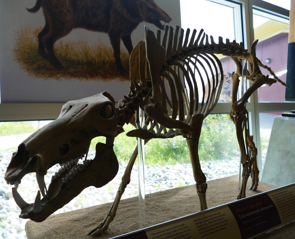
A single bone found in 1977 in northern Yukon was the first evidence that the wild bore (picture on wall behind the cast skeleton), a Flat-Headed Peccary, made it this far north in the America’s.
Flat-Headed Peccary
Fossils of the Scimitar Cat have been found in Texas and England, but rarely in the Beringia region. A limb was discovered in a gold mine in the permafrost near Dawson City, Yukon and DNA sequencing revealed these cats did roam this far north. The cast skull in the bottom of the photo is from a Sabretooth Cat found in California. There is no evidence of these cats in the Beringia region.
Scimitar Car
Skulls of (left to right) Black Bear, Grizzly Bear and the Giant Short-faced Bear
Comparison of Wolf and Grizzly Bear skulls
Our tour guide gave a demonstration in the use of the ATLATL, a spear throwing mechanism used to hunt animals. The arrow was placed on a lever, used to throw the arrow. As she put it, think of it as the ”chuck-it” dog toy thrower that you attach an arrow to.
Al trying his luck at getting ”dinner!” As you can see from all the arrows laying on the ground on the right side, none of us were successful at hunting!
Evidence of lions has been found.
As well as camels. Yes, camels roamed the Yukon!
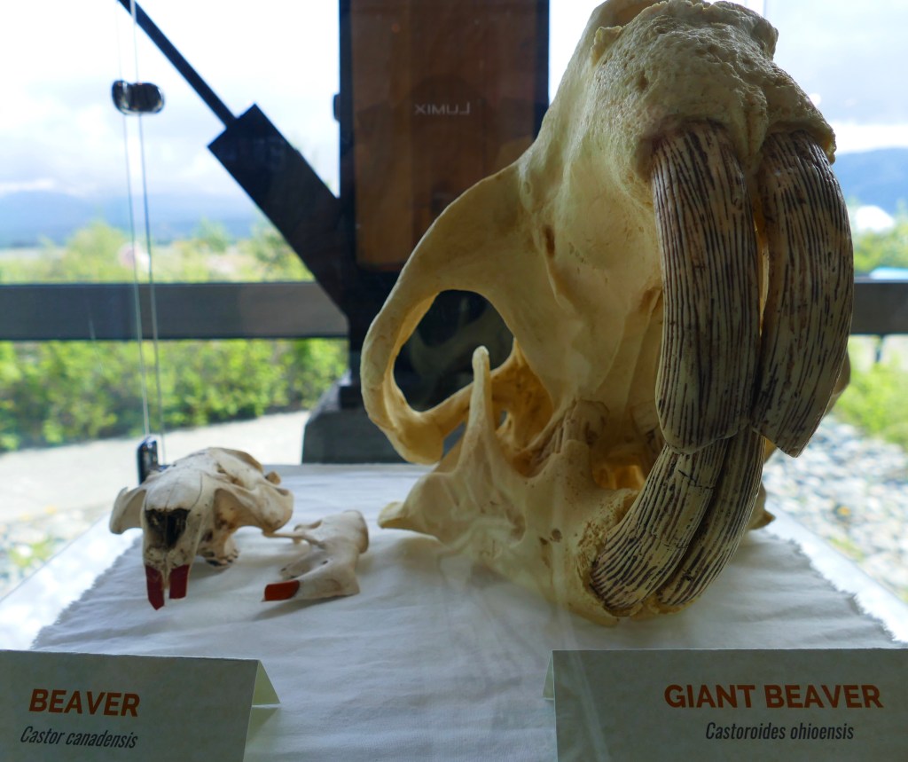
On our way into the museum, there is a statute of a Giant Beaver. Little did I know, these actually existed! So the model I’m standing next to, is really a life-size model. Nose to tail, they were 8 feet in length. They were the size of today’s black bear. It is the largest rodent known from the Pleistocene Epoch.
The Giant Beaver is real!
Below is a skull of the modern day beaver in comparison to a cast skull of the Giant Beaver!
If you go to the museum, make sure you take the time to watch the movie about the Beringia era. If was very informative, and discussed how the men digging for gold during the Klondike Gold Rush actually discovered many fossils that were stuck in the muck, also known as the permafrost region, which is about 60 meters deep in the Yukon.
Quote of the Day: ”We were meant to explore this earth like children do, unhindered by fear, propelled by curiosity and a sense of discovery. Allow yourself to see the world through new eyes and know there are amazing adventures here for you.” – Laurel Bleadon Maffe
Whitehorse has several museums to visit, but with limited time, we chose just two of them to see. The Yukon Transportation Museum and the Yukon Beringia Interpretive Centre are located next to each other, and have a combo pass for $12 Canadian. They both exceeded our expectations. There is room for RV’s in both parking lots. I’ll split the museums up in two posts, so it won’t get too long. .
Directly in front of the museum sits the world’s largest weathervane, a 1942 Douglas DC-3. You can read more about the history of this plane here
.
The museum contains a wide variety of exhibits covering the history of transportation in the Yukon. An early form of transportation in the Yukon.
This Concord stagecoach was used in the early 1900’s, by the White Pass and Yukon Route for use on the Overland Trail. The extreme weather and terrain proved to be too tough for this vehicle, and ended up being used as a mail truck in town.
Concord Stagecoach
A 1992 Chevrolet Caprice Classic was used by the Royal Canadian Mounted Police. In 1995, the blue was phased out, and all RCMP vehicles are now white.
A 1965 International Harvester Travelall 1000 Ambulance
The “old” and the “new” forms of vehicles that modernized the city of Whitehorse.
In September of 1945, after the war was over, the US and Canada agreed to let a bus service operate on the Alaska Highway. The British Yukon Navigation Company (BYN) operated a twice weekly bus service between Dawson City and Whitehorse until 1965. This is an old BYN Passenger Bus that was preserved in the condition it was found.
A 1954 Bombardier J5 Tractor, nicknamed “Fluffy the Snow Cat.” It was used by the Yukon Electric Company to pack and groom trails along the power lines that were not accessible by roadway.
A crop duster plane.
This HIller 360 CF-FAV Revival Gang helicopter was used for topographical surveys in the Yukon. In 1952, the pilot crashed due to a faulty fuel pump, and the pontoons snagged on the ground causing the helicopter to flip. The occupants were not injured and they abandoned the helicopter. Sixty-two years later it was recovered and restored for the museum.
A 1969 Bombardier 335 Olympique Skidoo was the successor to the 330 model which was used in the 1968 Expedition to the North Pole. Snowmobiles were, and continue to be, widely used to reach remote areas in the winter in the Yukon.
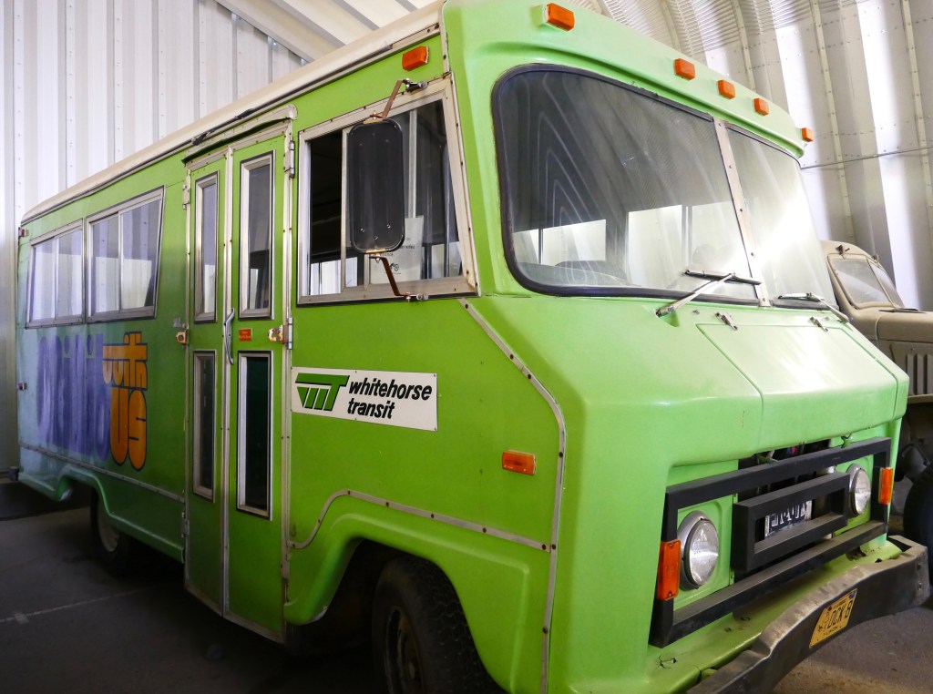
In 1974 the Yukon Status of Women Council formed a commission to study public transportation needs for women and children in Whitehorse. By 1975, the Yukon Women’s Mini-Bus Society was created, and they pursued a grant from Transport Canada. In 1976, this green passenger mini-bus, manufactured by Fleury Industries in Saskatchewan, Canada, was purchased by the city of Whitehorse with money awarded by the grant. The Women’s Mini-Bus Society operated the city’s only public transportation, providing women with non-traditional job opportunities. In 1978 the Whitehorse City Transit Commission was formed and took over the operation, but kept the original women employee’s on in their positions.
In 1920 Eva Hasell founded the Canadian Sunday School Caravan Mission. It was a way to provide Sunday school services to children in isolated communities in Western Canada. The van was staffed with two women, one trained in religious education, and the other as the driver/mechanic. The van had beds and camping gear in the back, and the women were known as ”Vanners.” This white 1956 Ford Chassis F-350 was converted into a Frontier Mission Van.
Below is a photograph from the museum with the above vehicle used at Haines Junction, Yukon, in the 1960’s.
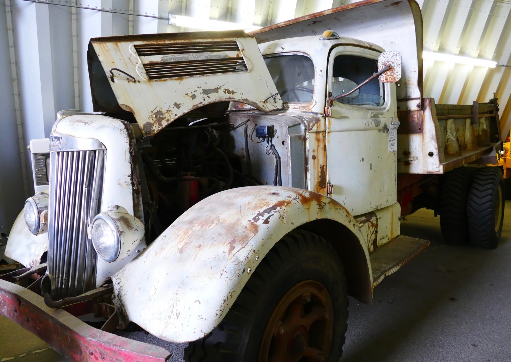
I always try to find something from our home state of Wisconsin in our travels. This 1950 Oshkosh W7000 (serial number 3780) truck was used for many tasks in the Yukon, from snow plowing, to a water tanker to minimize dusty conditions on the Alaska Highway. It remained in service until 1964.
This 1942 Fordson 9N tractor reminded Dan and I of the yellow tractor that he used the past six summers working at Teton Cabins. I’m not sure what the make/model of ”big Yellow” as Dan called it was, but it looks very similar to this.
After finishing up the Yukon Transportation Museum, the four of us walked next door to the Beringian Museum, which will be the next post.
Quote of the Day: “A visit to a museum is a search for beauty, truth, and meaning in our lives. Go to museums as often as you can.” – Maira Kalman
Karen and Al caught up to us in Whitehorse, after getting their 5th wheel repaired. They had no issues, despite all the bumps, potholes and frost heaves. Whitehorse is the last big city before arriving in Alaska, and there are plenty of things to see and do in the town. If coming through this area, you should definitely plan on spending a few days here.
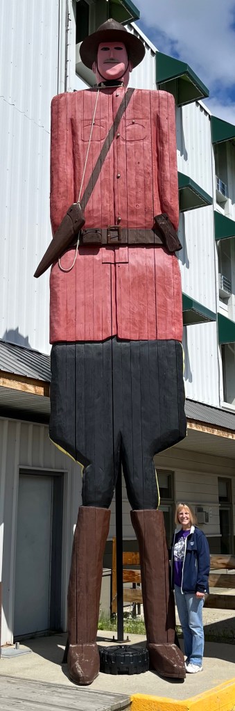
While driving around downtown, there was a tall statute outside a hotel that caught my eye, so Dan was instructed to turn around and pull into the parking lot.
And then I found a fuzzier version of the RCMP the next day.
We did a quick exterior tour of the SS Klondike Riverboat, which was built in Whitehorse. It was used to carry silver-lead ore through the narrow, winding rivers. It is currently undergoing renovations. Hopefully it will reopen later this year, and maybe we will consider stopping at it when we come back through in August.
The riverboat paddle wheel was covered up by a tarp for repairs.
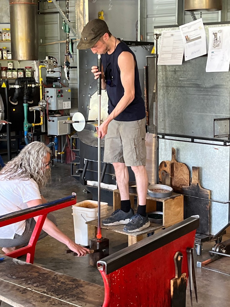
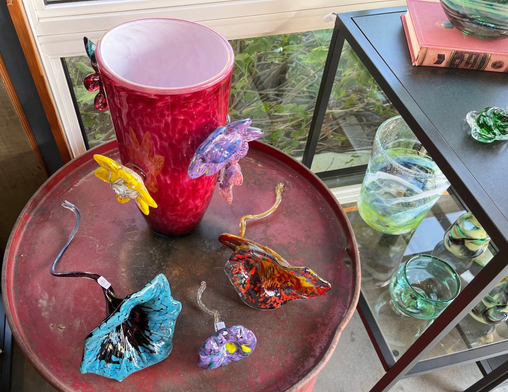
Lumel Glass Blowing Studios was another stop on our tour of Whitehorse. A young man was busy making a glass for a local real estate agent. She gives them out as gifts to clients. It took about 15 minutes to make the glass, and then it “cools” in a 500 degree oven for 9 – 12 hours. He did a nice job explaining the process as he was making it. He has been doing this for 15 years. They keep the doors open as much as possible, as it gets close to 100 degrees inside the building.
Heating up the glassBlowing the glass
He was using various tools to shape/form the glass. Notice the woman behind him, heating up some glass in another oven.
The woman is adding what will become the base of the glass to the other piece.
I was surprised by how involved this process is. They have a lot of beautiful glass work on display, and they do many custom orders.
I did post a video of him making the glass on Instagram. For those not on IG, you can watch it here. If there’s no sound, you can “unmute” it on the bottom right corner of the video.
We have entered our third province, or rather territory, in Canada: Yukon. It’s our last section before we enter into Alaska. The Alaska Highway goes in and out of Yukon and British Columbia seven times.
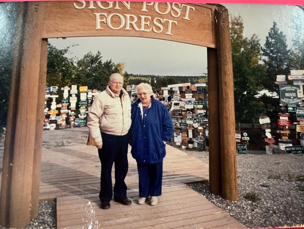
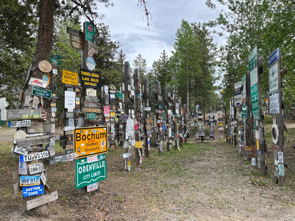
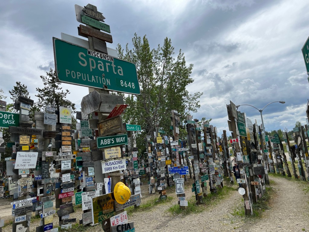
The big touristy thing to do in Watson Lake is a stop at the Sign Post Forest. During the construction of the highway, the United States Army had put up a directional sign for Watson Lake. Private Carl Lindley was injured during the construction of the road, and was recuperating in Watson Lake. He was ordered to repair and paint the directional posts and he decided to make a sign for his hometown of Danville, Illinois and added it to the post. Eventually other soldiers added their hometowns to the post, and the rest, as they say, is history.
In September of 1992, Carl and his wife Elinor returned to Watson Lake to commemorate the 50th anniversary of the Alaska Highway. I took a photograph of that photo at the museum. Unfortunately no one knows what happened to the original sign post. This place is now on the registry of Yukon Historical Sites. So it will be forever preserved.
Thirty years after Carl and Elinor, we have arrived!
June 6, 2022
They estimate there are now over 100,000 signs posted here in the Sign Post Forest. The place is amazing! When we first started walking towards it, I told Dan that it seemed smaller than I thought it would be. After a few minutes of wandering around, he asked if I still thought it was small – no it is not! I think a lot of cities/towns and villages are missing some street signs – they can be found here! All 50 states and many countries are represented.
Quote of the Day: “When we are lost in the woods, the sight of a signpost is a great matter.” – C. S. Lewis